
It is located in Velykoseletske village, Seletskyi Starostat (administrative division), Orzhytsia territorial community, Lubny district, Poltava region, on the eastern edge of the central part of the village.
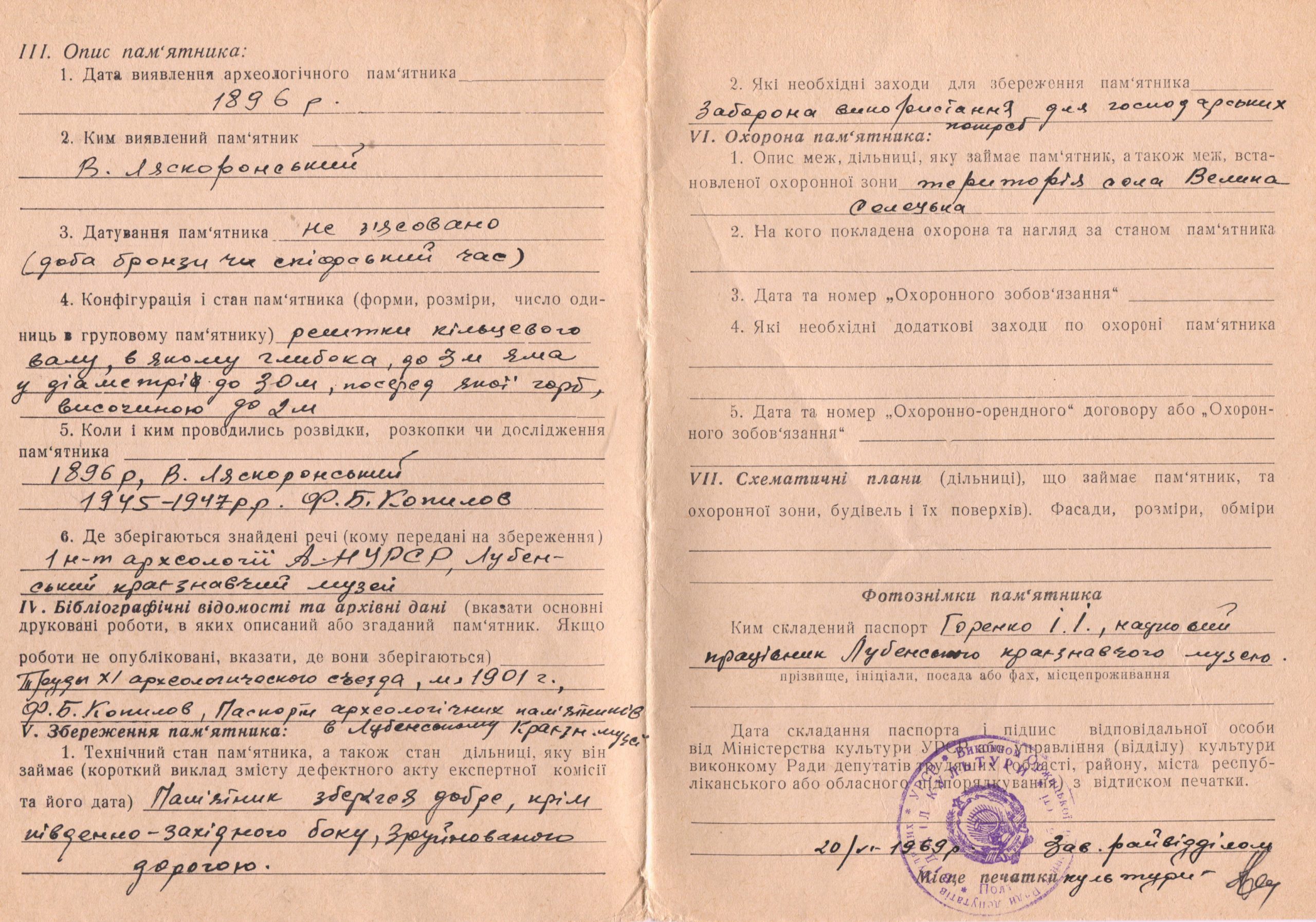
The site has been known since the end of 19th c., it was examined by V. H. Liaskoronskyi (1880 – 1890s), F. B. Kopylov (1945), H. O. Sydorenko (1974, 1975), O. M. Tkachenko (1989), V. M. Vereshchaka (2006), R. S. Luhovyi, V. V. Kasian, O. V. Kovalenko (2012), V. V. Sherstiuk (2014, 2016, 2019, 2021).
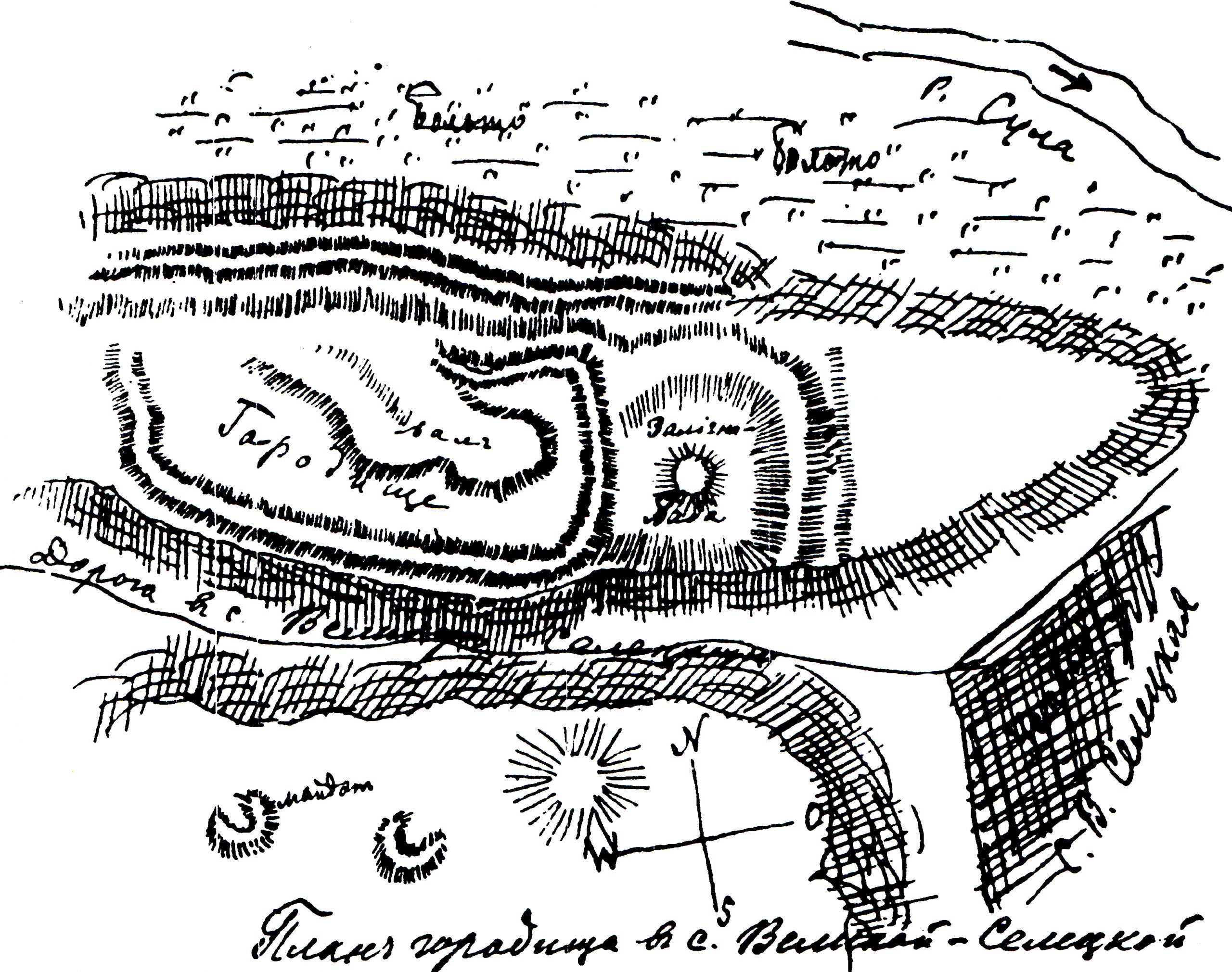
The first rather informative description of “Zalizna Baba” was given by V. H. Liaskoronskyi. In his opinion, the branches of the square were the remains of the Slavonic fortified settlement.This researcher’s doubtful assumption was most likely prompted by the existence of escarpments at the ravine slope, which were actually the remains of the Posullia Zmiiovyi Val (Snake Breastwork) fortifications.
L.V. Padalka gives the information about at least 20 tombs on the northern village edge, 10 of which were of “Roblenyi” type, i.e. the squares, as well as “triangular breastworks similar to shooting grounds” (probably, the branches of “Zalizna Baba” or similar saltpeter production complexes).
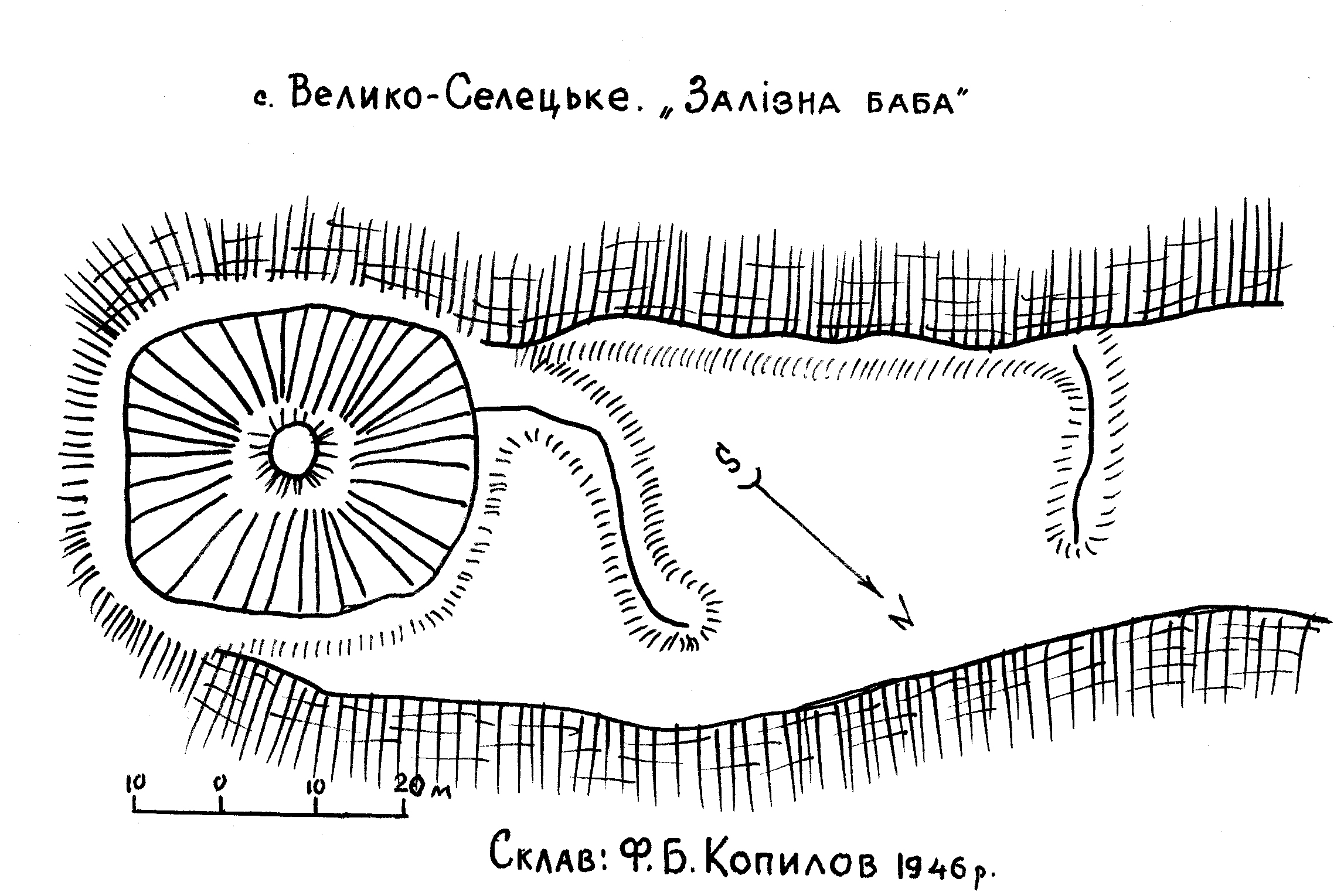
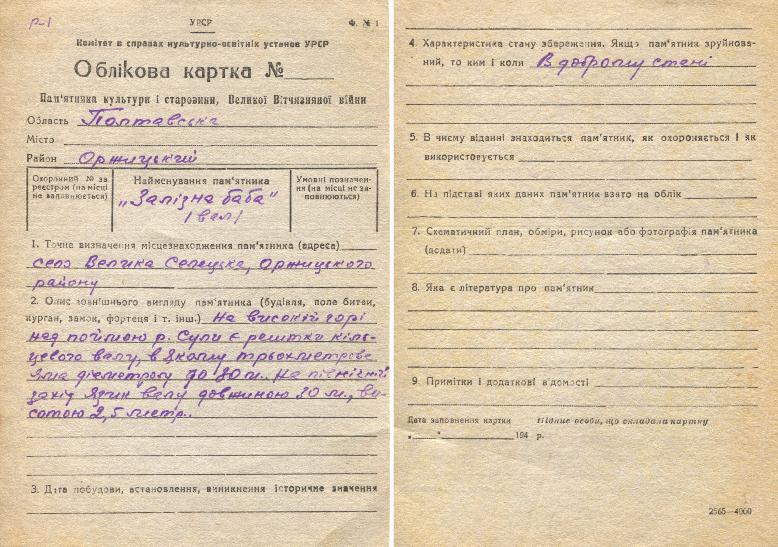
After the examination of “Zalizna Baba” and “Bila Mohyla (White Tomb) from the opposite side of the road…” in 1945 by the expedition group, headed by F. B. Kopylov, the latter opposed V. H. Liaskoronskyi in relation to “fortified settlement” origin of “Zalizna Baba” embankments. F. B. Kopylov properly noted that they were actually the “square breastworks” while fairly categorizing other soil structures on Lysa Hora as the cemetery diking. He also created the first reporting card for this site.
The first attempt, probably, based on the results of the field trip examination, belongs to the end of 1960-s. It was taken by I. I. Horenko, а research staff member of the Lubny Museum of Local Lore, who produced the passport for the archaeological site “Zalizna Baba” Sacrificial Altar. This name was given to it at that time due to lack of popularity and grounds for the square and saltpeter production origin of such objects.
In 1974-1975, upon the examination of “Zalizna Baba” square by the employees of the Poltava Museum of Local Lore, mainly, H. O. Sydorenko and V. O. Paidem, aimed at the creation of the reporting documents for this site, the architect F. Kvas drew up its plan and V. O. Paidem took some photos of its appearance at that time. The square was still called “Zalizna Baba” Sacrificial Altar” – not a historically accurate, but a very mysterious name, surrounded by legends. At the same time, even back then the author of the passport H. O. Sydorenko was making some cautious remarks in relation to the nature of the site:“….if it is not a square”.
So, even in the second half of the 20th c. this saltpeter production site was considered to be and recorded as the Slavonic and Ancient Rus sacrificial altar both in accounting records and different reference books. The reason for that, most likely, was not only the square complex form and the lack of research into the origin of squares in general, but also numerous legends and traditional stories about this site, circulating among the locals, as well as the proximity of such great Old Rus complexes as Lukimske and Tarasivske fortified settlements and some findings in the village itself.
The latest several examinations were done by V. V. Sherstiuk: In 2014 and 2017 for the inventory of the archaeological sites within Orzhytsia district and to prepare further accounting documents for them. Mainly the results of these examinations and historical investigations became the subject for V.V. Sherstiuk’s several academic papers and new accounting documents, approved in 2019.
In 2019 the site territory was examined for the production of orthophotomaps and 3D-models, done jointly by the Center for Preservation and Investigation of Archaeological Sites and the Deputy Director of Bilsk historical and cultural conservation area O. V. Korotia. As a result, the latter created 3D-model of the site.
It occupies the edge of the right root sloping bank of the Sula River.
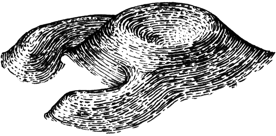
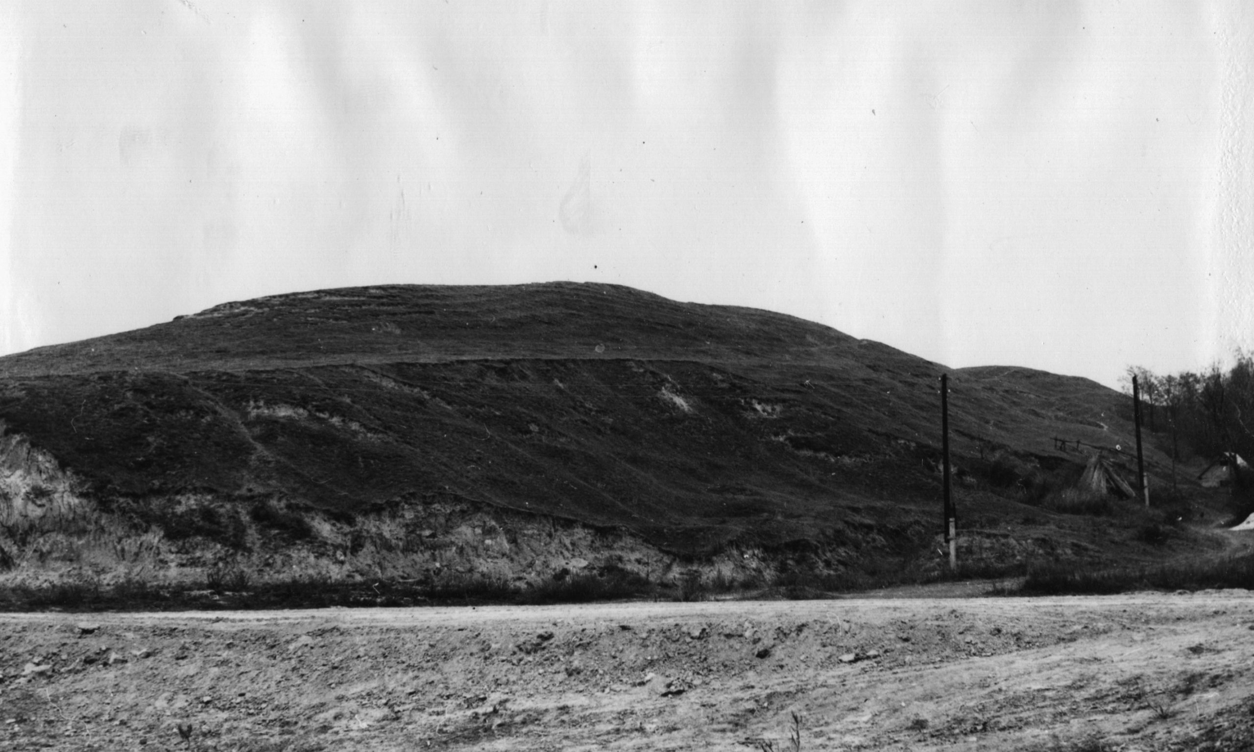
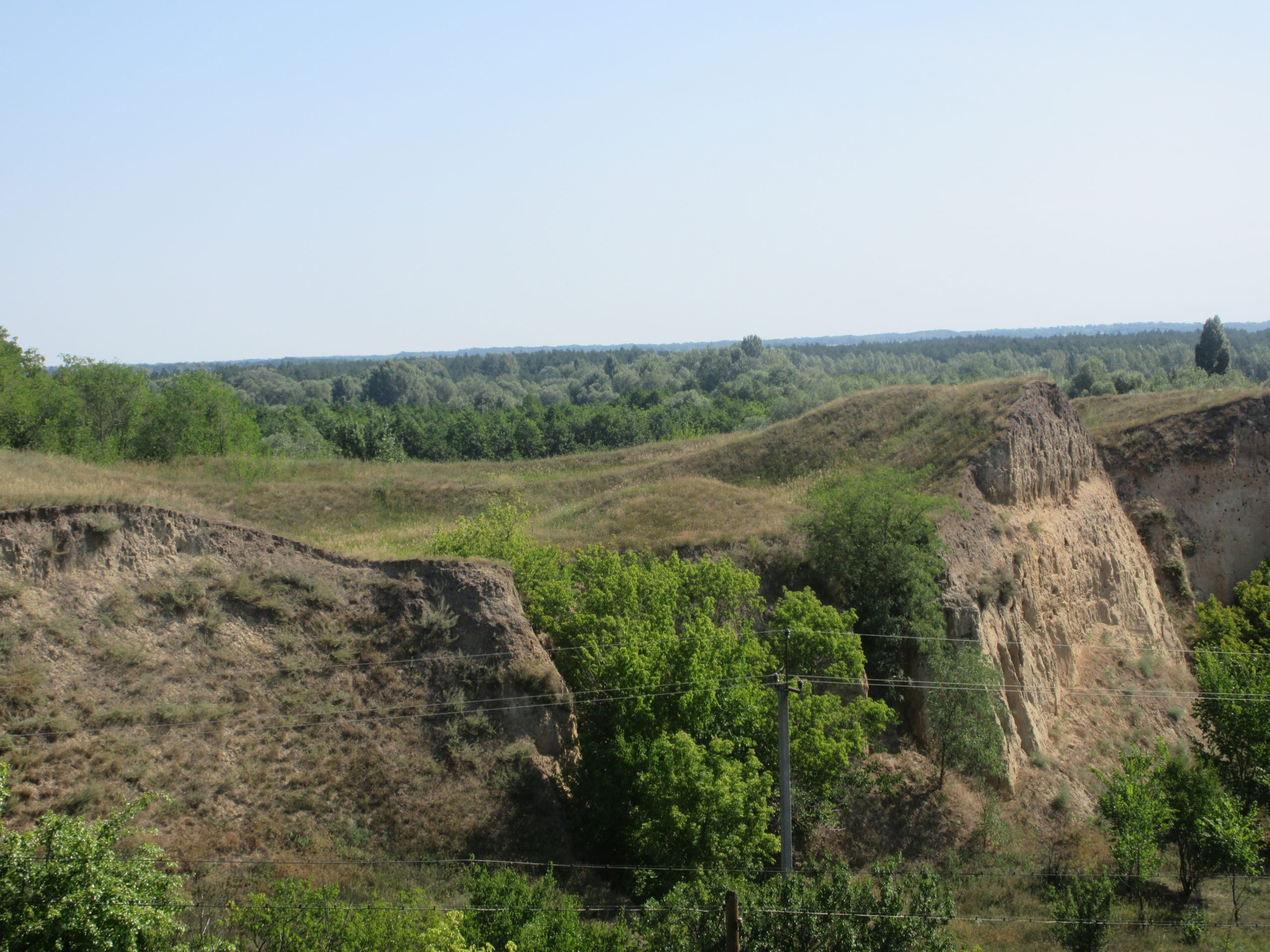
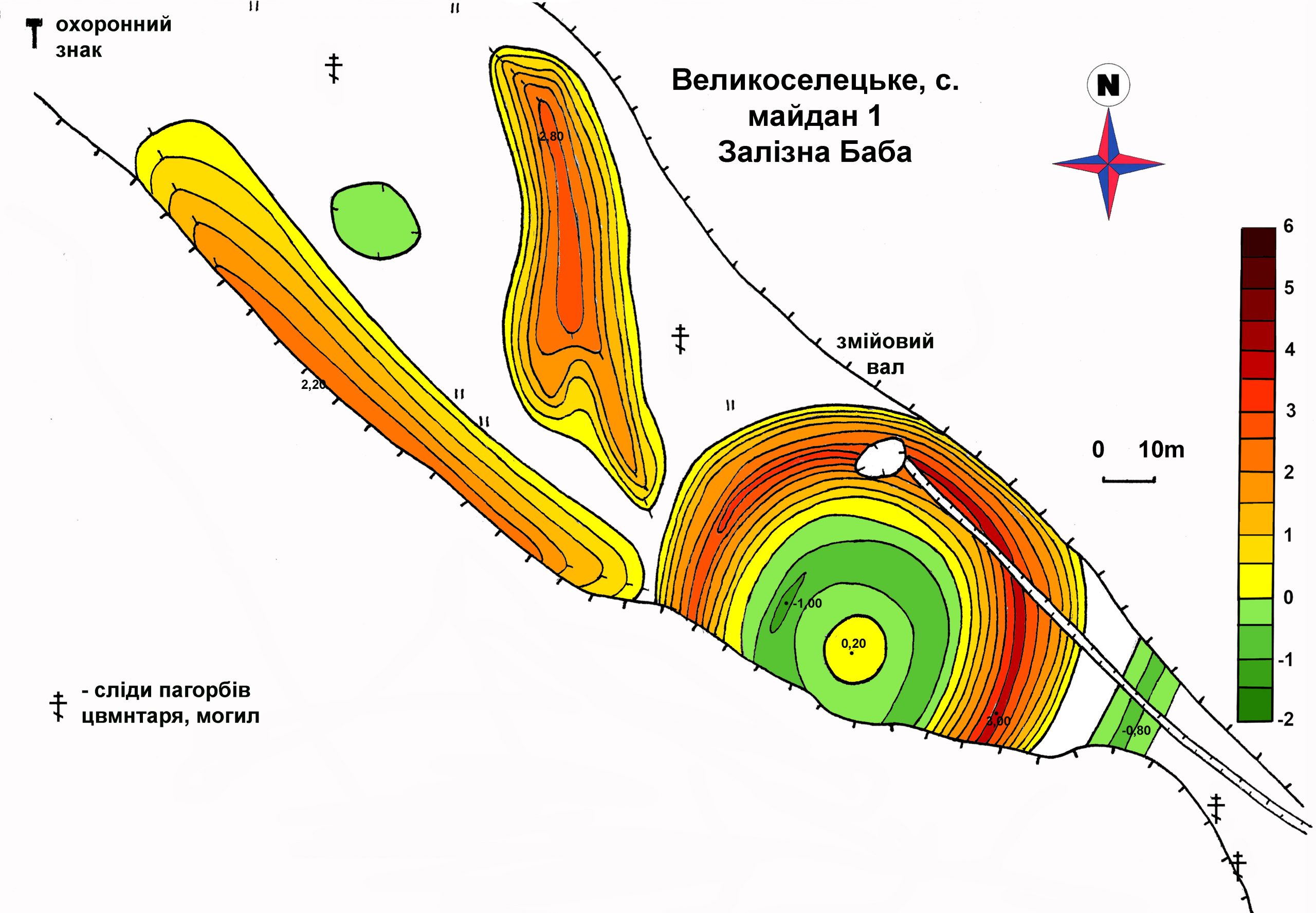
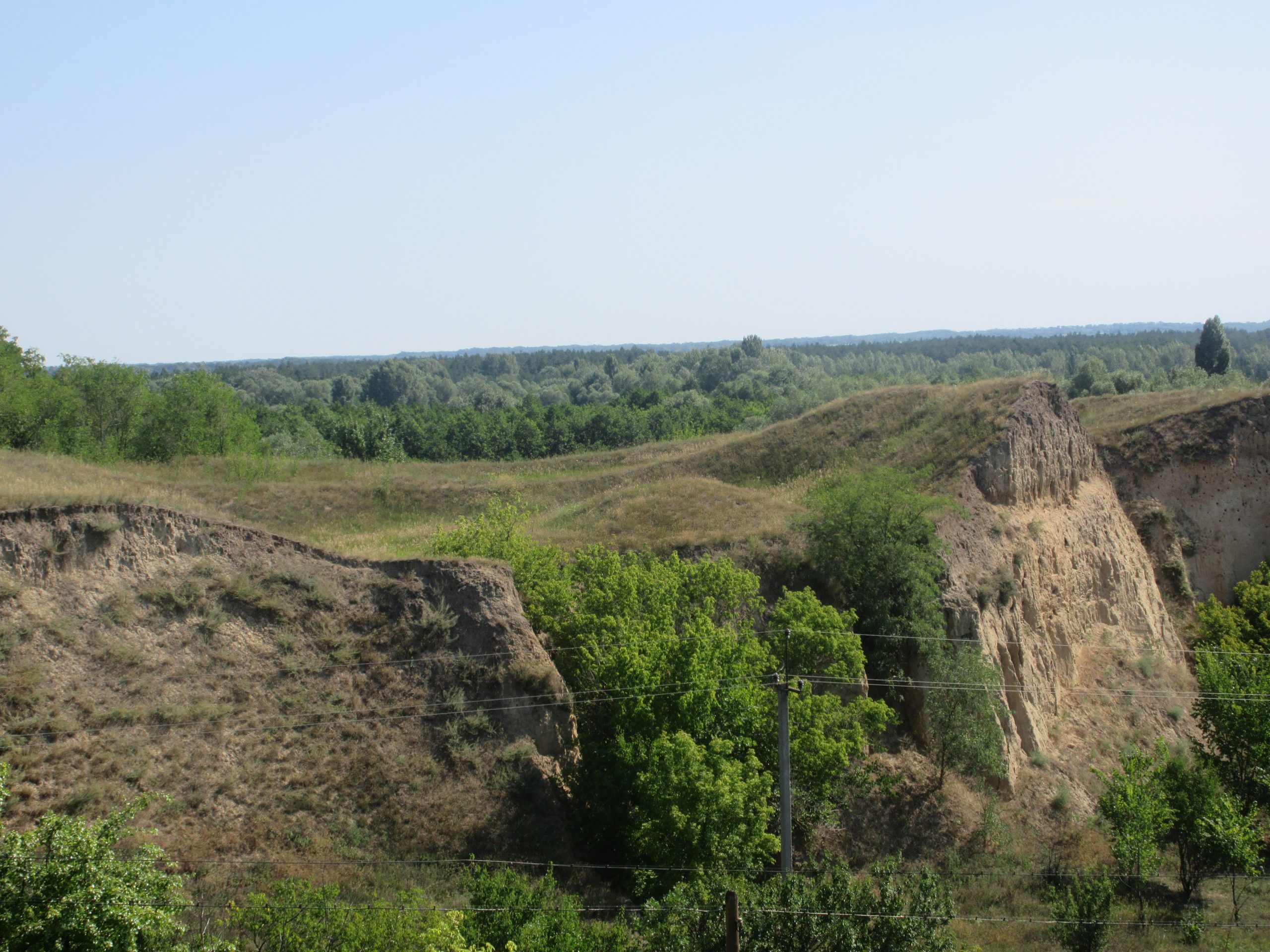
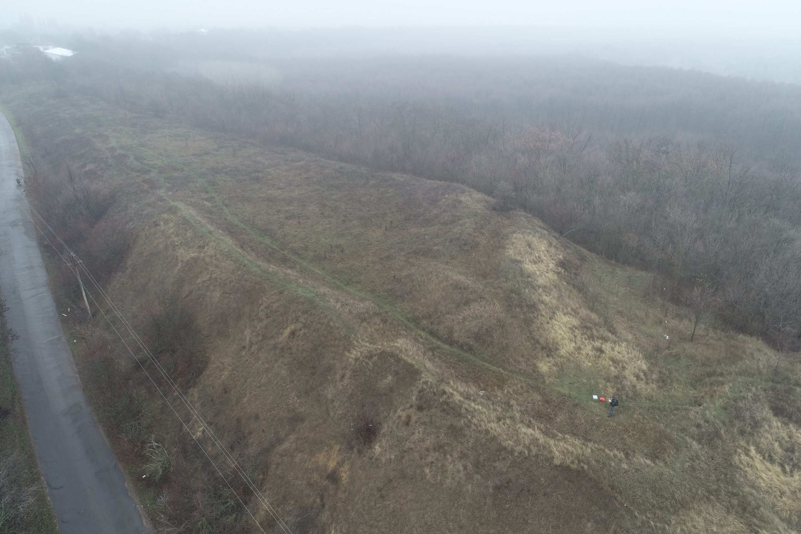
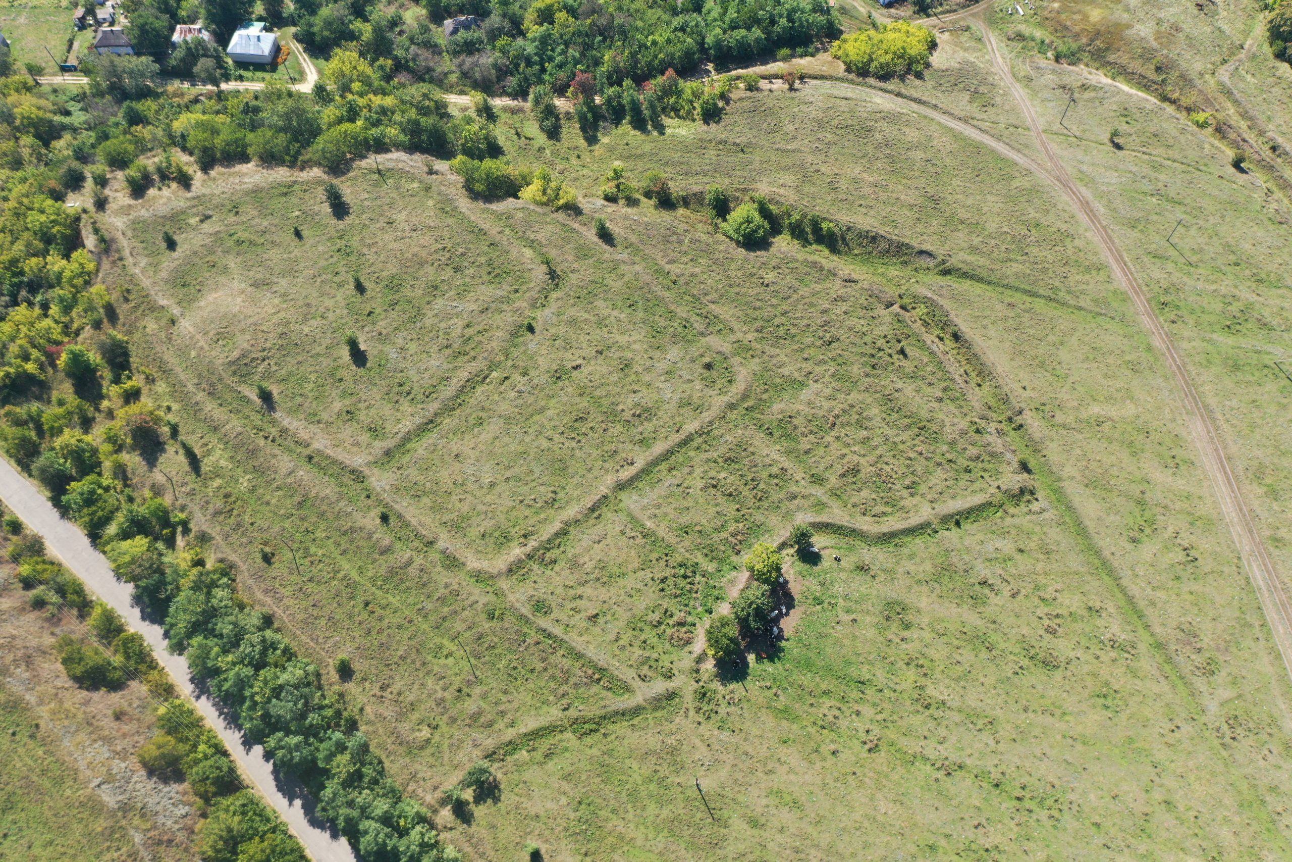
“Zalizna Baba” square is quite similar to classic saltpeter production squares and comprises a circular residual and a couple of branches. The kurgan circular residual in the southern part was mostly destroyed because of root terrace washing out due to the functioning of the borrow pit for the brick plant and the levelling of a new road. Its maximal dimensions are: 75 m (on the remaining axis north-west – south-east) x 35 m (in the opposite direction, on the axis, containing destroyed section). Its maximal height is traced in the north-eastern part of the residual and makes up to 3.0 m from the level of the surrounding daylight surface. The traces of the break-up (the entrance) from the side of the branches are almost absent. The total area (including the space within the square branches) is 0.552 ha.
In the centre of the hollow, located considerably lower than the current daylight surface level, there is a preserved hill, with relative height of 1.2 m from the maximal hollow depth and 20 m in diameter (its part also shattered).On the ravine steep slope it can be observed that the residual complex is placed on the loamy soil base.
Both V. H. Liaskoronskyi and later F. B. Kopylov noted that in this particular area the locals when digging discovered the remains of some burnt and compacted clay, bricks, an iron pickaxe with a narrow neck and other findings. Besides, the former emphasized that particularly this hill was called “Zalizna Baba” among the locals. The name for the whole square derived from it, as, according to a traditional story, the stone statue with human head features – eyes, a nose, a mouth etc. – was found there. Unfortunately, at that time its afterlife had already been unknown.
There is a chance that this folklore story keeps the reflection of the real Early Iron Age stone stele remains discovery in the square complex, which could have been on the top of a big (judging from the remaining size) Scythian times kurgan before its processing to saltpeter.
The saltpeter production process from the Scythian times embankment apparently occurred, judging from the similar sites in our region, in the 1st half of the 18th c. At that time Orzhytsia area was one of the biggest centres of the saltpeter business development of the Left Bank Ukraine, where two major “companies” dealt with production: B. Obalkovskyi’s royal “saltpeter state” and a “private” one by the Vyshnevetski magnates.
Later stories, collected by V. Posukhov, focus on already classic legendary tales about the Scythian kurgans with a golden horse and the iron maiden in this context had already become a woman-protector form the invaders in this area. Though, during the examination in 1974 the locals were telling the employees of the Poltava Museum of Local Lore that this site was a place for making sacrifice, even human ones, in general the stories about the woman-protector were used as a basis for the current village emblem: “Against red background there is a sorceress with golden hair, wearing a silver gown and a sky-blue cloak, holding a golden sword in her right hand, riding a horse, stepping on three green hills. The coat of arms is framed with an ornamental сartouche and crowned with a golden village crown.
In the north-eastern circular residual section there is a hollow (provably, a dugout shelter), from which a ditch stretches along the river bank slope to the south-east. Its origin is currently vague. It is possible that these are the traces of the 2nd World War trenches; at least, in the photo of 1975 from the accounting documents it still had freshly exposed collapsed parts.
On the south-eastern edge of the circular residual one can observe a small ditch with a relative depth down to -0.80m, crossing a narrow neck, marked and described as far back as by V.H. Lyaskoronskyi. At the moment its origin is vague – Those can be the remains of a circular ditch of the Scythian times original embankment.
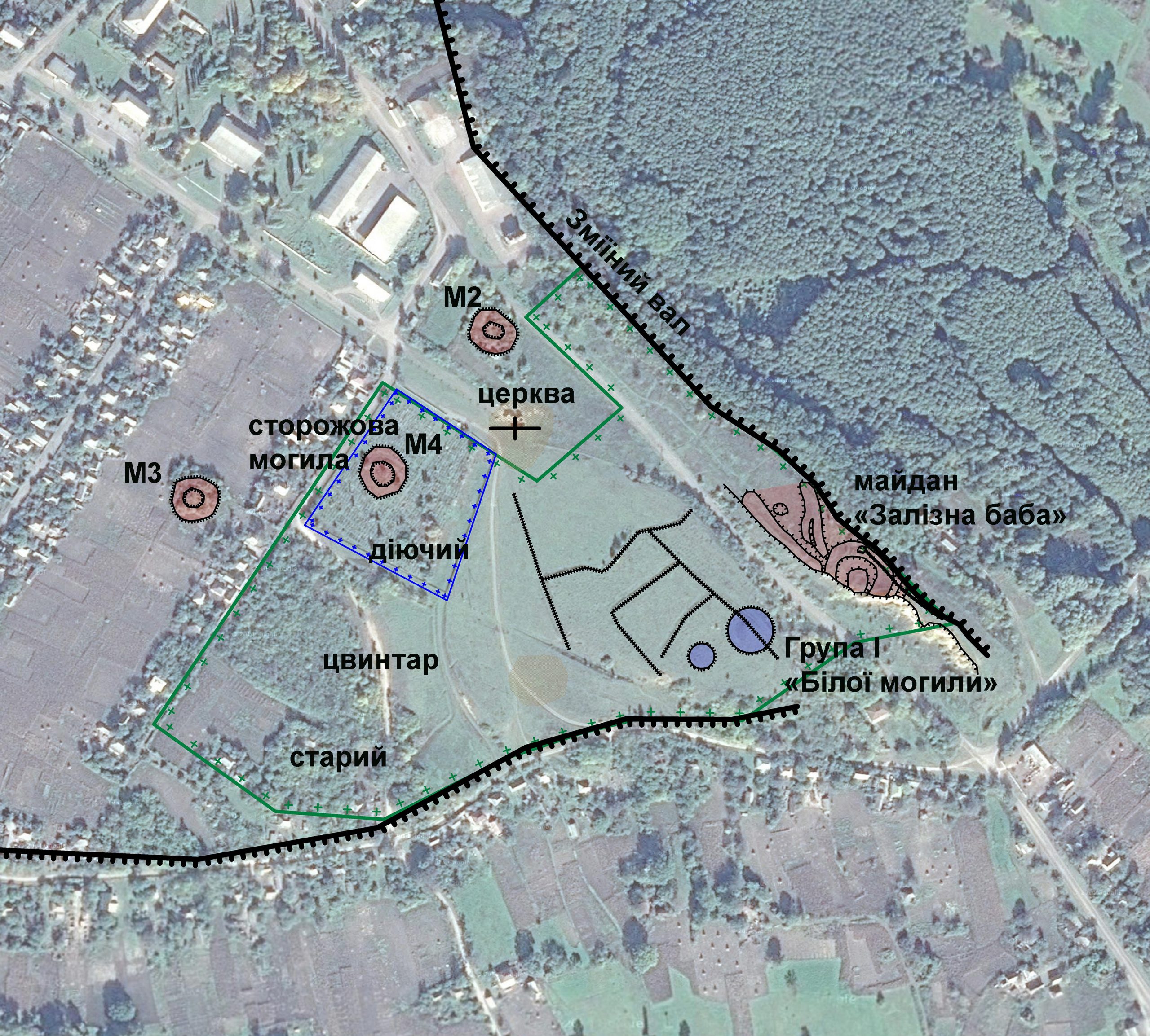
To the north-west from the circular residual, deeper into the bank plateau, there is a pair of branches.
The right branch is fully preserved, its maximal height is 2.80 m in its northern part, while in its southern part there is a hollow in the centre, stretching for about half of its length. Based on this, it can be concluded that this branch had two components that, in general, is typical of these structures in our region. Its length is 60 m and maximal width is 17 m.
The left branch, located at the edge of ravine, has partially collapsed from the south-west. Its maximal height in the central part is 2.20 m, the length is 87 m and the currently preserved maximal width is up to 13 m. Such a straight-line and asymmetrical location (relative to the right branch) is not typical, but quite understandable, if one takes into account the fact that it was located directly at the ravine steep slope edge, which later was additionally cut. On the layouts by V. H. Liaskoronskyi and F. B. Kopylov this branch in ending in a small curve, this is not observable now.
The old model of the protection sign is preserved to north-west from the end of this “small breastwork”. Between the branches, in the middle of the square there is a hollow, a common detail of similar square complexes.
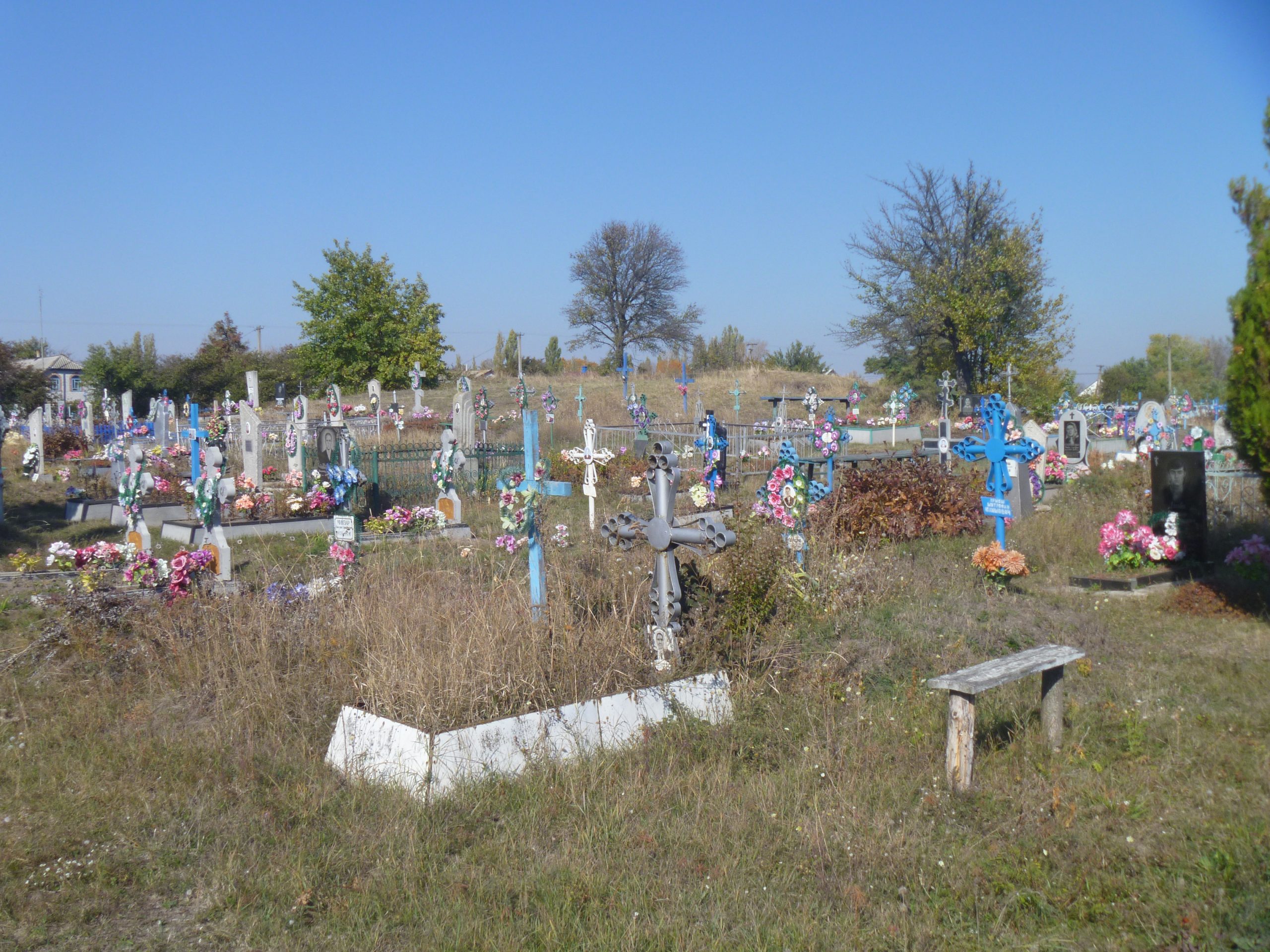
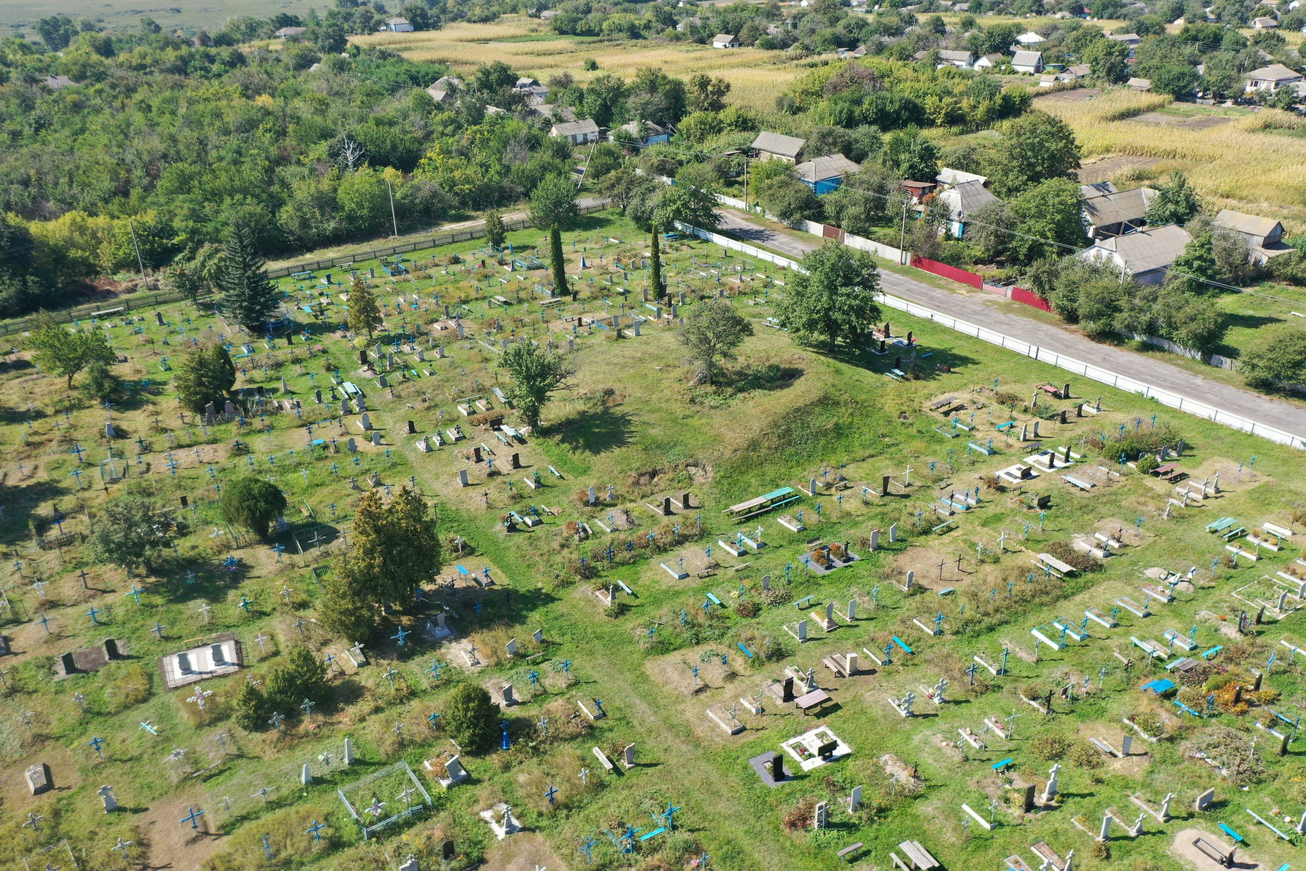
Starting from the end of the 19th c., all the above-mentioned territory within and around the square was occupied by a cemetery, some traces of the modern times ground burials in the ravine exposed walls were observed by F. B. Kopylov in the middle of the 20 c. They are explicitly observable even now, especially in the south-east section, in the exposed areas of ravine and collapsed parts, closer to the foot of its steep slope.
To the north and north-east the square is surrounded by the root sloping bank edge, additionally protected by the section of the Posullia Zmiiovyi Val, which V. H. Liaskoronskyi believed to be the part of the Slavonic settlement fortification, while O. B. Suprunenko hypothesized that it could have been the remains of the fortification structure of the 2nd half of the 17th c. However, these “breastworks”, most likely were either the diking lines for the cemeteries that belong to different periods of time, or the square branches themselves. The construction of the fortresses in common settlement of the Left Bank Ukraine was not typical for those times, moreover, for not even a sotnia town, but some minor settlement, which Velykа SeІeletska was even in the 2nd half of the 18th c.
Probably, under the root sloping bank massif over “Zalizna Baba”, a few underground passages appeared in the modern times, that were described by an eyewitness as follows:“… three passages of 7-8 metres long, … One is 2 metres high and with the same width, the walls are smoothly cut and also burnt. Apparently, for some time the subterrane was used as cellars for local peasants. At the moment these objects have not been recorded.
The site specified belongs to typical saltpeter production sites of the 1st half of the 17th c. as one of the largest similar square complexes of the Posullia, which was establish at the site of a big Scythian times embankment.
Though only “Zalizna Baba” square is the archaeological site within the village, but a number of archaeological sites in the nearest neighbourhood both contextually and territorially tend to it.
7th – 4th cc. BC, 17th c., the Scythian and the Cossacks times.
It is located in Velykoseletske village, Seletskyi Starostat (administrative division), Orzhytsia territorial community, Lubny district, Poltava region, on the eastern edge of the central part of the village.
The site has been known since the end of 19th c., it was examined by V. H. Liaskoronskyi (1880 – 1890s), F. B. Kopylov (1945), H. O. Sydorenko (1974, 1975), O. M. Tkachenko (1989), V. M. Vereshchaka (2006), R. S. Luhovyi, V. V. Kasian, O. V. Kovalenko (2012), V. V. Sherstiuk (2014, 2016, 2019, 2021).
The first rather informative description of “Zalizna Baba” was given by V. H. Liaskoronskyi. In his opinion, the branches of the square were the remains of the Slavonic fortified settlement.This researcher’s doubtful assumption was most likely prompted by the existence of escarpments at the ravine slope, which were actually the remains of the Posullia Zmiiovyi Val (Snake Breastwork) fortifications.
L.V. Padalka gives the information about at least 20 tombs on the northern village edge, 10 of which were of “Roblenyi” type, i.e. the squares, as well as “triangular breastworks similar to shooting grounds” (probably, the branches of “Zalizna Baba” or similar saltpeter production complexes).
After the examination of “Zalizna Baba” and “Bila Mohyla (White Tomb) from the opposite side of the road…” in 1945 by the expedition group, headed by F. B. Kopylov, the latter opposed V. H. Liaskoronskyi in relation to “fortified settlement” origin of “Zalizna Baba” embankments. F. B. Kopylov properly noted that they were actually the “square breastworks” while fairly categorizing other soil structures on Lysa Hora as the cemetery diking. He also created the first reporting card for this site.
The first attempt, probably, based on the results of the field trip examination, belongs to the end of 1960-s. It was taken by I. I. Horenko, а research staff member of the Lubny Museum of Local Lore, who produced the passport for the archaeological site “Zalizna Baba” Sacrificial Altar. This name was given to it at that time due to lack of popularity and grounds for the square and saltpeter production origin of such objects.
In 1974-1975, upon the examination of “Zalizna Baba” square by the employees of the Poltava Museum of Local Lore, mainly, H. O. Sydorenko and V. O. Paidem, aimed at the creation of the reporting documents for this site, the architect F. Kvas drew up its plan and V. O. Paidem took some photos of its appearance at that time. The square was still called “Zalizna Baba” Sacrificial Altar” – not a historically accurate, but a very mysterious name, surrounded by legends. At the same time, even back then the author of the passport H. O. Sydorenko was making some cautious remarks in relation to the nature of the site:“….if it is not a square”.
So, even in the second half of the 20th c. this saltpeter production site was considered to be and recorded as the Slavonic and Ancient Rus sacrificial altar both in accounting records and different reference books. The reason for that, most likely, was not only the square complex form and the lack of research into the origin of squares in general, but also numerous legends and traditional stories about this site, circulating among the locals, as well as the proximity of such great Old Rus complexes as Lukimske and Tarasivske fortified settlements and some findings in the village itself.
The latest several examinations were done by V. V. Sherstiuk: In 2014 and 2017 for the inventory of the archaeological sites within Orzhytsia district and to prepare further accounting documents for them. Mainly the results of these examinations and historical investigations became the subject for V.V. Sherstiuk’s several academic papers and new accounting documents, approved in 2019.
In 2019 the site territory was examined for the production of orthophotomaps and 3D-models, done jointly by the Center for Preservation and Investigation of Archaeological Sites and the Deputy Director of Bilsk historical and cultural conservation area O. V. Korotia. As a result, the latter created 3D-model of the site.
It occupies the edge of the right root sloping bank of the Sula River.
“Zalizna Baba” square is quite similar to classic saltpeter production squares and comprises a circular residual and a couple of branches. The kurgan circular residual in the southern part was mostly destroyed because of root terrace washing out due to the functioning of the borrow pit for the brick plant and the levelling of a new road. Its maximal dimensions are: 75 m (on the remaining axis north-west – south-east) x 35 m (in the opposite direction, on the axis, containing destroyed section). Its maximal height is traced in the north-eastern part of the residual and makes up to 3.0 m from the level of the surrounding daylight surface. The traces of the break-up (the entrance) from the side of the branches are almost absent. The total area (including the space within the square branches) is 0.552 ha.
In the centre of the hollow, located considerably lower than the current daylight surface level, there is a preserved hill, with relative height of 1.2 m from the maximal hollow depth and 20 m in diameter (its part also shattered).On the ravine steep slope it can be observed that the residual complex is placed on the loamy soil base.
Both V. H. Liaskoronskyi and later F. B. Kopylov noted that in this particular area the locals when digging discovered the remains of some burnt and compacted clay, bricks, an iron pickaxe with a narrow neck and other findings. Besides, the former emphasized that particularly this hill was called “Zalizna Baba” among the locals. The name for the whole square derived from it, as, according to a traditional story, the stone statue with human head features – eyes, a nose, a mouth etc. – was found there. Unfortunately, at that time its afterlife had already been unknown.
There is a chance that this folklore story keeps the reflection of the real Early Iron Age stone stele remains discovery in the square complex, which could have been on the top of a big (judging from the remaining size) Scythian times kurgan before its processing to saltpeter.
The saltpeter production process from the Scythian times embankment apparently occurred, judging from the similar sites in our region, in the 1st half of the 18th c. At that time Orzhytsia area was one of the biggest centres of the saltpeter business development of the Left Bank Ukraine, where two major “companies” dealt with production: B. Obalkovskyi’s royal “saltpeter state” and a “private” one by the Vyshnevetski magnates.
Later stories, collected by V. Posukhov, focus on already classic legendary tales about the Scythian kurgans with a golden horse and the iron maiden in this context had already become a woman-protector form the invaders in this area. Though, during the examination in 1974 the locals were telling the employees of the Poltava Museum of Local Lore that this site was a place for making sacrifice, even human ones, in general the stories about the woman-protector were used as a basis for the current village emblem: “Against red background there is a sorceress with golden hair, wearing a silver gown and a sky-blue cloak, holding a golden sword in her right hand, riding a horse, stepping on three green hills. The coat of arms is framed with an ornamental сartouche and crowned with a golden village crown.
In the north-eastern circular residual section there is a hollow (provably, a dugout shelter), from which a ditch stretches along the river bank slope to the south-east. Its origin is currently vague. It is possible that these are the traces of the 2nd World War trenches; at least, in the photo of 1975 from the accounting documents it still had freshly exposed collapsed parts.
On the south-eastern edge of the circular residual one can observe a small ditch with a relative depth down to -0.80m, crossing a narrow neck, marked and described as far back as by V.H. Lyaskoronskyi. At the moment its origin is vague – Those can be the remains of a circular ditch of the Scythian times original embankment.
To the north-west from the circular residual, deeper into the bank plateau, there is a pair of branches.
The right branch is fully preserved, its maximal height is 2.80 m in its northern part, while in its southern part there is a hollow in the centre, stretching for about half of its length. Based on this, it can be concluded that this branch had two components that, in general, is typical of these structures in our region. Its length is 60 m and maximal width is 17 m.
The left branch, located at the edge of ravine, has partially collapsed from the south-west. Its maximal height in the central part is 2.20 m, the length is 87 m and the currently preserved maximal width is up to 13 m. Such a straight-line and asymmetrical location (relative to the right branch) is not typical, but quite understandable, if one takes into account the fact that it was located directly at the ravine steep slope edge, which later was additionally cut. On the layouts by V. H. Liaskoronskyi and F. B. Kopylov this branch in ending in a small curve, this is not observable now.
The old model of the protection sign is preserved to north-west from the end of this “small breastwork”. Between the branches, in the middle of the square there is a hollow, a common detail of similar square complexes.
Starting from the end of the 19th c., all the above-mentioned territory within and around the square was occupied by a cemetery, some traces of the modern times ground burials in the ravine exposed walls were observed by F. B. Kopylov in the middle of the 20 c. They are explicitly observable even now, especially in the south-east section, in the exposed areas of ravine and collapsed parts, closer to the foot of its steep slope.
To the north and north-east the square is surrounded by the root sloping bank edge, additionally protected by the section of the Posullia Zmiiovyi Val, which V. H. Liaskoronskyi believed to be the part of the Slavonic settlement fortification, while O. B. Suprunenko hypothesized that it could have been the remains of the fortification structure of the 2nd half of the 17th c. However, these “breastworks”, most likely were either the diking lines for the cemeteries that belong to different periods of time, or the square branches themselves. The construction of the fortresses in common settlement of the Left Bank Ukraine was not typical for those times, moreover, for not even a sotnia town, but some minor settlement, which Velykа SeІeletska was even in the 2nd half of the 18th c.
Probably, under the root sloping bank massif over “Zalizna Baba”, a few underground passages appeared in the modern times, that were described by an eyewitness as follows:“… three passages of 7-8 metres long, … One is 2 metres high and with the same width, the walls are smoothly cut and also burnt. Apparently, for some time the subterrane was used as cellars for local peasants. At the moment these objects have not been recorded.
The site specified belongs to typical saltpeter production sites of the 1st half of the 17th c. as one of the largest similar square complexes of the Posullia, which was establish at the site of a big Scythian times embankment.
Though only “Zalizna Baba” square is the archaeological site within the village, but a number of archaeological sites in the nearest neighbourhood both contextually and territorially tend to it.
7th – 4th cc. BC, 17th c., the Scythian and the Cossacks times.
Read moreПам’яткоохоронна інформація
Monument protection information
Пам’ятка археології місцевого значення.
Наказ Міністерства культури, молоді та спорту України № 1062 від 25.02.2020 р.
охоронний номер 2678-Пл.
maidan_i_zalizna_baba_oblikova_kartka_w-1.pdfПам’ятка археології місцевого значення.
Наказ Міністерства культури, молоді та спорту України № 1062 від 25.02.2020 р.
охоронний номер 2678-Пл.
maidan_i_zalizna_baba_oblikova_kartka_w-1.pdfНаукові публікації
Scientific publications
Шерстюк В., Ткаченко О., Луговий Р., Коваленко О. Майдан “Залізна баба” // Звід пам’яток історії та культури України: Полтавська область. Оржицький район / Упоряд., наук. ред. та передм. В. О. Мокляк. Полтавський краєзнавчий музей ім. В. Кричевського. – Полтава: TOB “АСМІ”, 2015. – С. 85-87
orzhyczkyj-zvod-zalizna-baba-miscz-pam.pdfШерстюк В., Ткаченко О., Луговий Р., Коваленко О. Майдан “Залізна баба” // Звід пам’яток історії та культури України: Полтавська область. Оржицький район / Упоряд., наук. ред. та передм. В. О. Мокляк. Полтавський краєзнавчий музей ім. В. Кричевського. – Полтава: TOB “АСМІ”, 2015. – С. 85-87
orzhyczkyj-zvod-zalizna-baba-miscz-pam.pdf
Шерстюк В. Майдан «Залізна Баба» та комплекс пам’яток округи с. Великоселецьке // Полтавський краєзнавчий музей: Маловідомі сторінки історії, музеєзнавство, охорона пам’яток: збірник наукових статей / Департ. культури і туризму Полтав. ОДА; ПКМ імені Василя Кричевського; [ред. кол.: Бабенко Л. Л., Вождаєнко В. В., Гаврилюк Н. О. та ін.; гол. ред. кол. Супруненко О. Б.; наук. ред. Мокляк В. О.]. – Полтава : Дивосвіт, 2018. – С. 61-72
2018-sherstyuk-v.-v.-majdan-zalizna-baba-ta-kompleks-pamyatok-okrugy-s.-velykoseleczke.-pkm.pdfШерстюк В. Майдан «Залізна Баба» та комплекс пам’яток округи с. Великоселецьке // Полтавський краєзнавчий музей: Маловідомі сторінки історії, музеєзнавство, охорона пам’яток: збірник наукових статей / Департ. культури і туризму Полтав. ОДА; ПКМ імені Василя Кричевського; [ред. кол.: Бабенко Л. Л., Вождаєнко В. В., Гаврилюк Н. О. та ін.; гол. ред. кол. Супруненко О. Б.; наук. ред. Мокляк В. О.]. – Полтава : Дивосвіт, 2018. – С. 61-72
2018-sherstyuk-v.-v.-majdan-zalizna-baba-ta-kompleks-pamyatok-okrugy-s.-velykoseleczke.-pkm.pdfШерстюк В. Коротка історична довідка об’єкта культурної спадщини: Майдан «Залізна баба», с. Великоселецьке, Селецька сільська рада, Оржицький район, Полтавська область
korotka_istorychnv_dovidka_w.pdfШерстюк В. Коротка історична довідка об’єкта культурної спадщини: Майдан «Залізна баба», с. Великоселецьке, Селецька сільська рада, Оржицький район, Полтавська область
korotka_istorychnv_dovidka_w.pdf Майдан «Залізна баба». Облікова картка 1980-х рр.
Майдан «Залізна баба». Облікова картка 1980-х рр.
Фотогалерея
Gallery
Великоселецьке, с. Майдан «Залізна баба». Фото, 1975 р.
Великоселецьке, с. Майдан «Залізна баба». План з горизонталями висот.
Великоселецьке, с. Майдан «Залізна баба». Загальний вигляд. Фото, 2014 р.
План комплексу пам’яток у с. Великоселецьке. Програмна оболонка – Global Mapper, основа – космознімок SAS Planet.
План «городища» за В. Г. Ляскоронським, 1901
План 1945—1946 років Ф. Б. Копилова.
Перша облікова картка, укладена у 1940-х рр. на «Залізну бабу». Автор — Ф. Б. Копилов.
Розгортка першого паспорту 1969 р. на пам’ятку археології. Автор — І. І. Горенко.
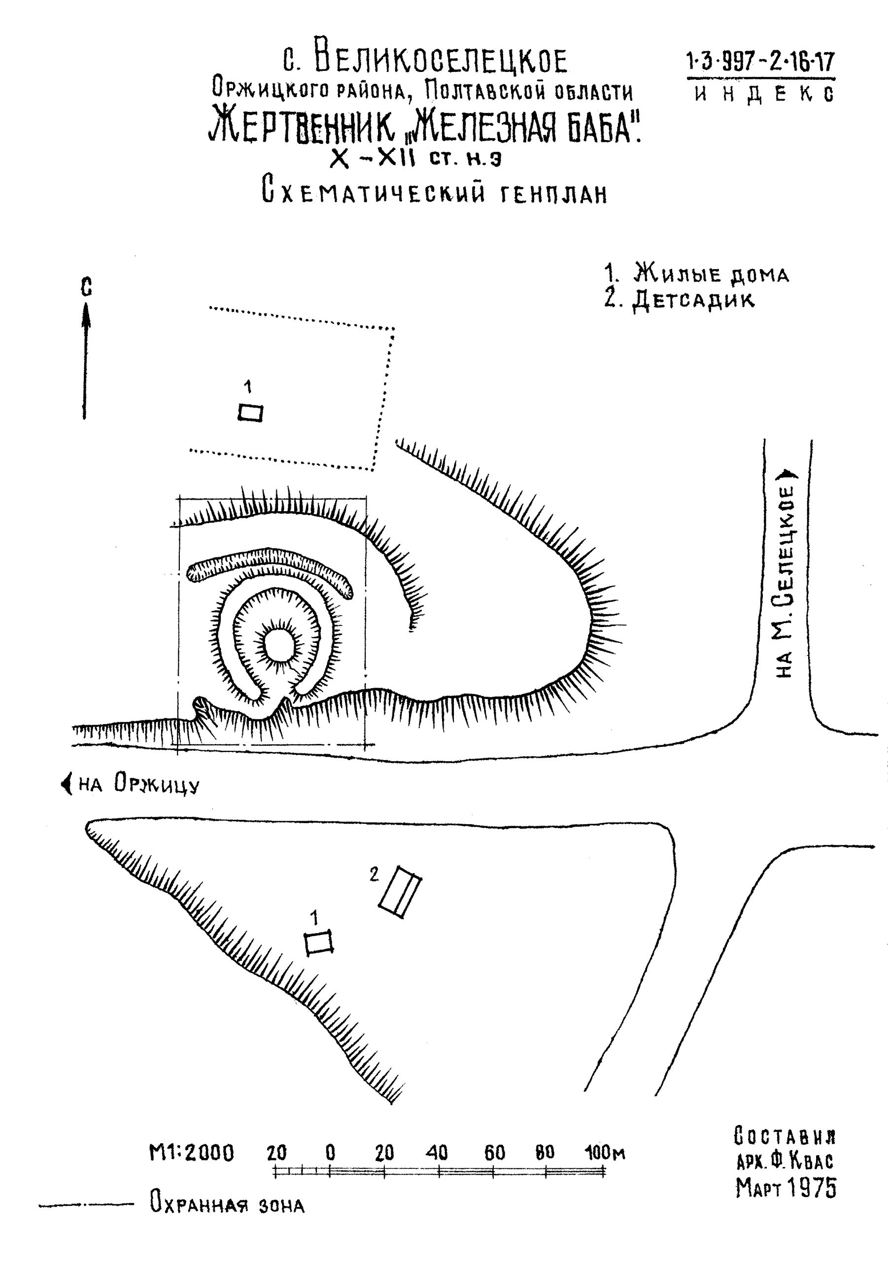
План «Залізної баби» [Укладений Ф. Квасом] із паспорту 1974 р.
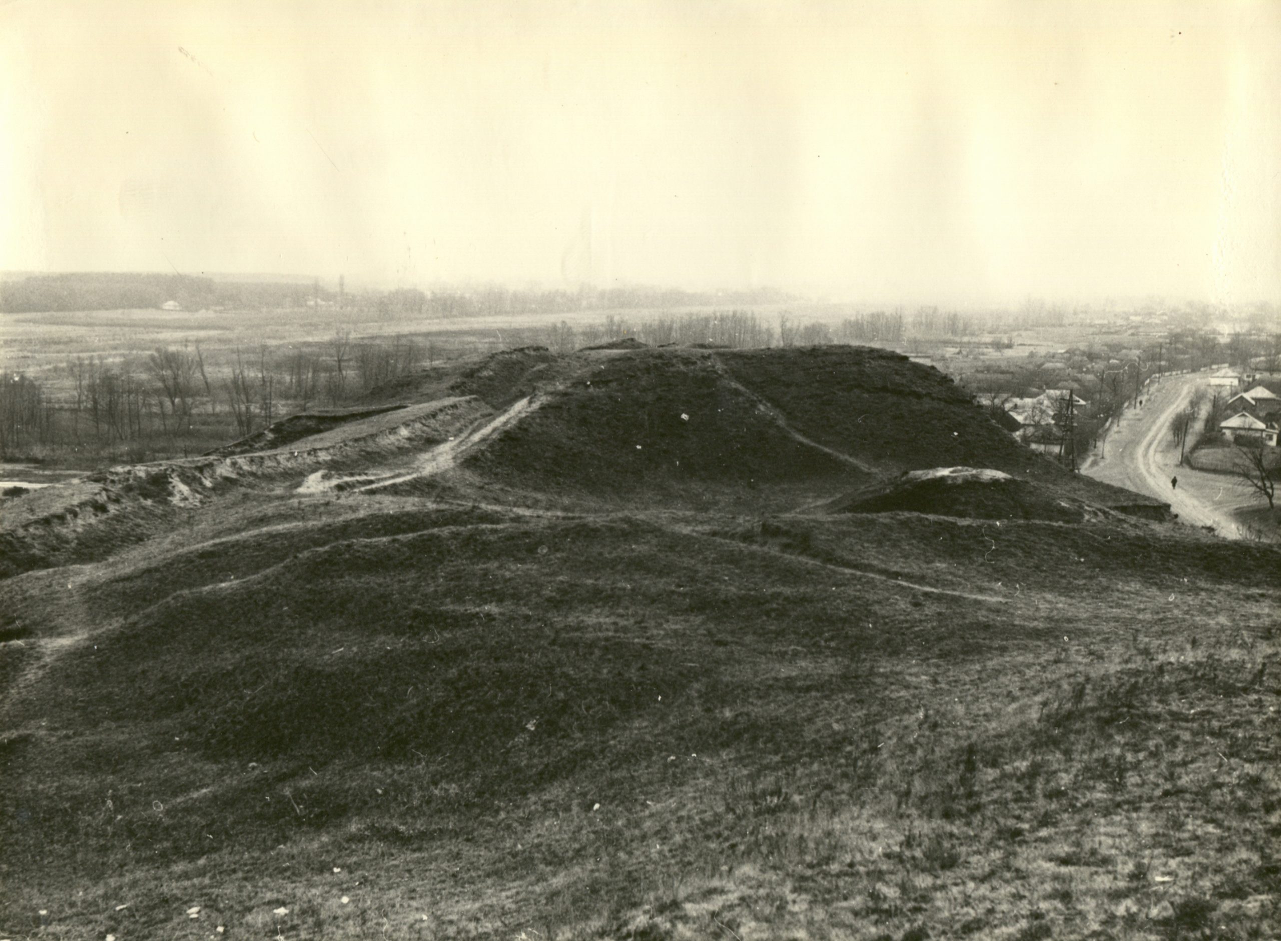
Загальний вигляд майдану в 1974 р. Фото В. О. Пайдема.
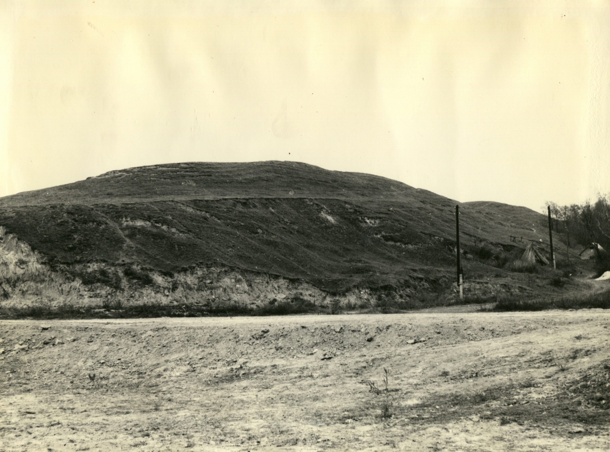
Загальний вигляд майдану в 1974 р. Фото В. О. Пайдема.
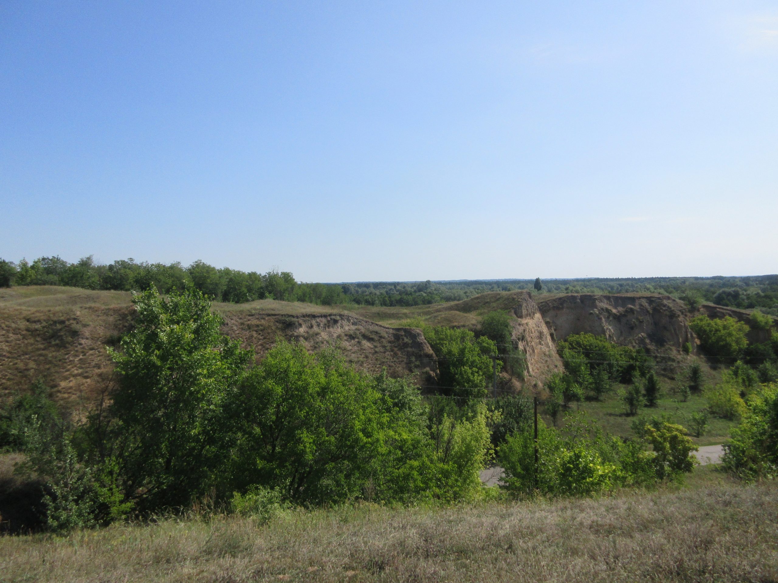
Вигляд «Залізної баби» з Білої могили. 2014 р.

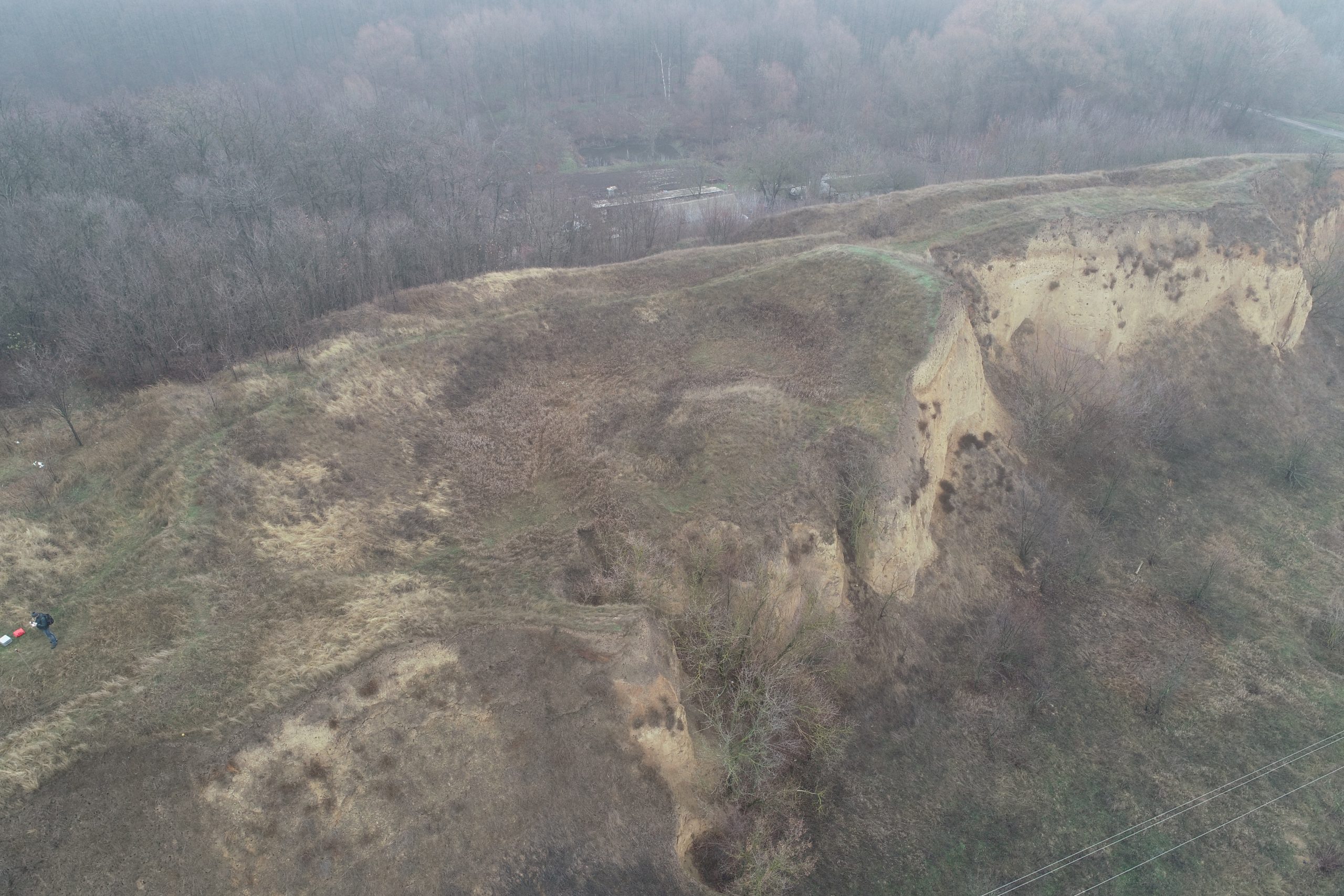
Майдан, фото з квадрокоптера. 2021 р.
План, за В. Шерстюком, 2018 р.
Кільцевий останець кургану. Фото 2019 р. з квадрокоптера.
Підвищення в западині останця. Фото 2014 р.
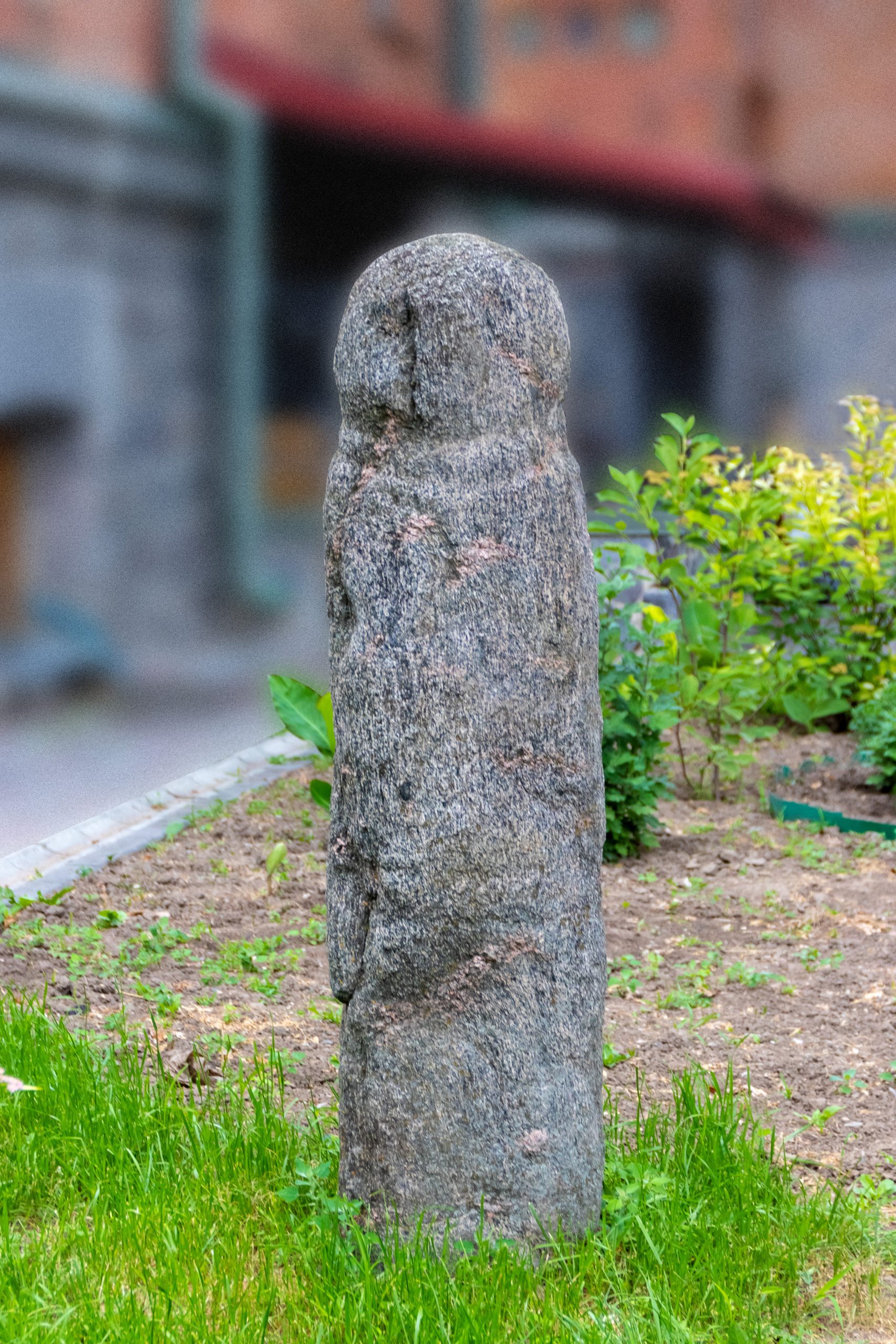
Кам’яна стела скіфського часу із зібрання Полтавського краєзнавчого музею з с. Шедієве. Саме така «кам’яна баба» могла дати ім’я майдану. Фото Є. Калініна
Вуса майдану, фото зі сторони кільцевого останця. Фото з квадрокоптера 2019 р.
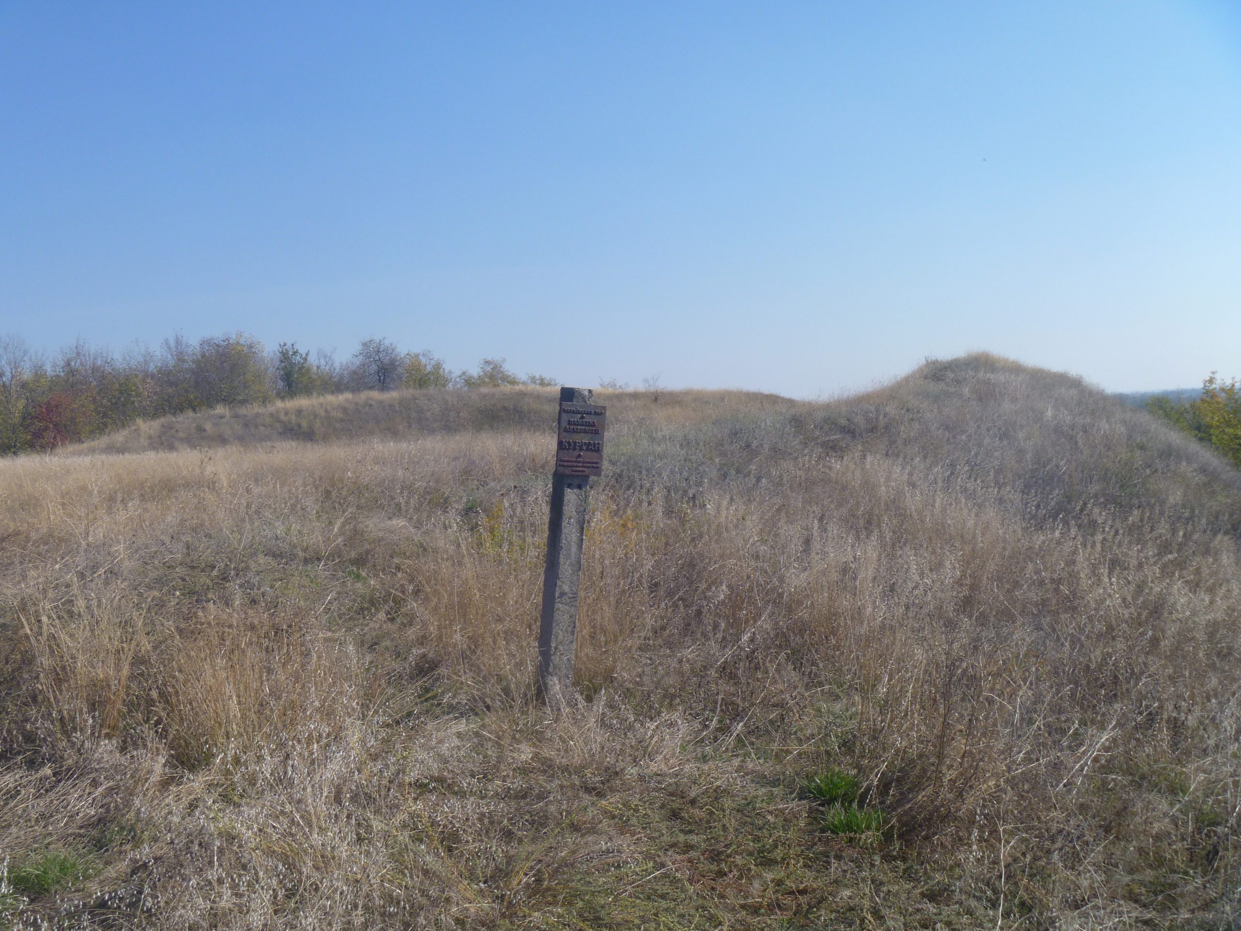
Охоронний знак пам’ятки археології. Фото 2014 р.
Майдан 1 групи майданів І. Фото 2014 р.
Майдан 1 групи майданів І. Фото 2014 р.
Лиса гора. Вигляд зі сторони Залізної баби/ Фото з квадрокоптера 2019 р.
Лиса гора. Вигляд зі сторони Залізної баби/ Фото з квадрокоптера 2019 р.
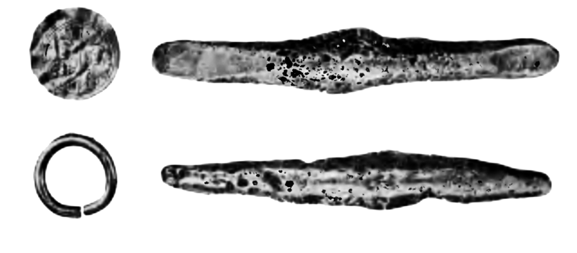
Знахідки зі складу скарбів, знайдених на поч. ХХ ст.: золоті візантійська монета та кільце, срібні гривнеподібні зливки. За: Отчет 1904; 1906.
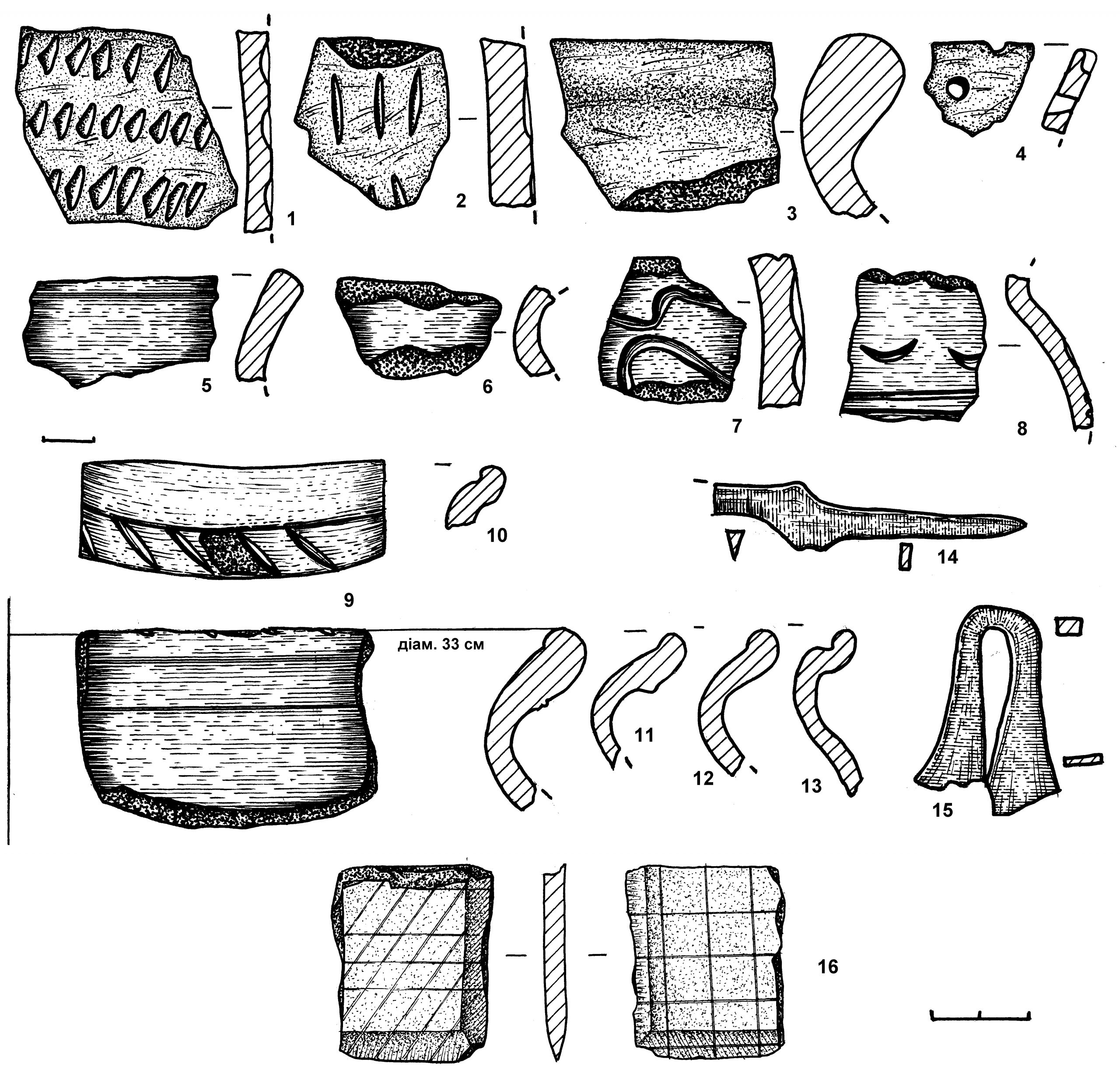
Пункт Великоселецьке І. Знахідки. 1-13 – кераміка. 14-15 – залізо, 16 – сланець.
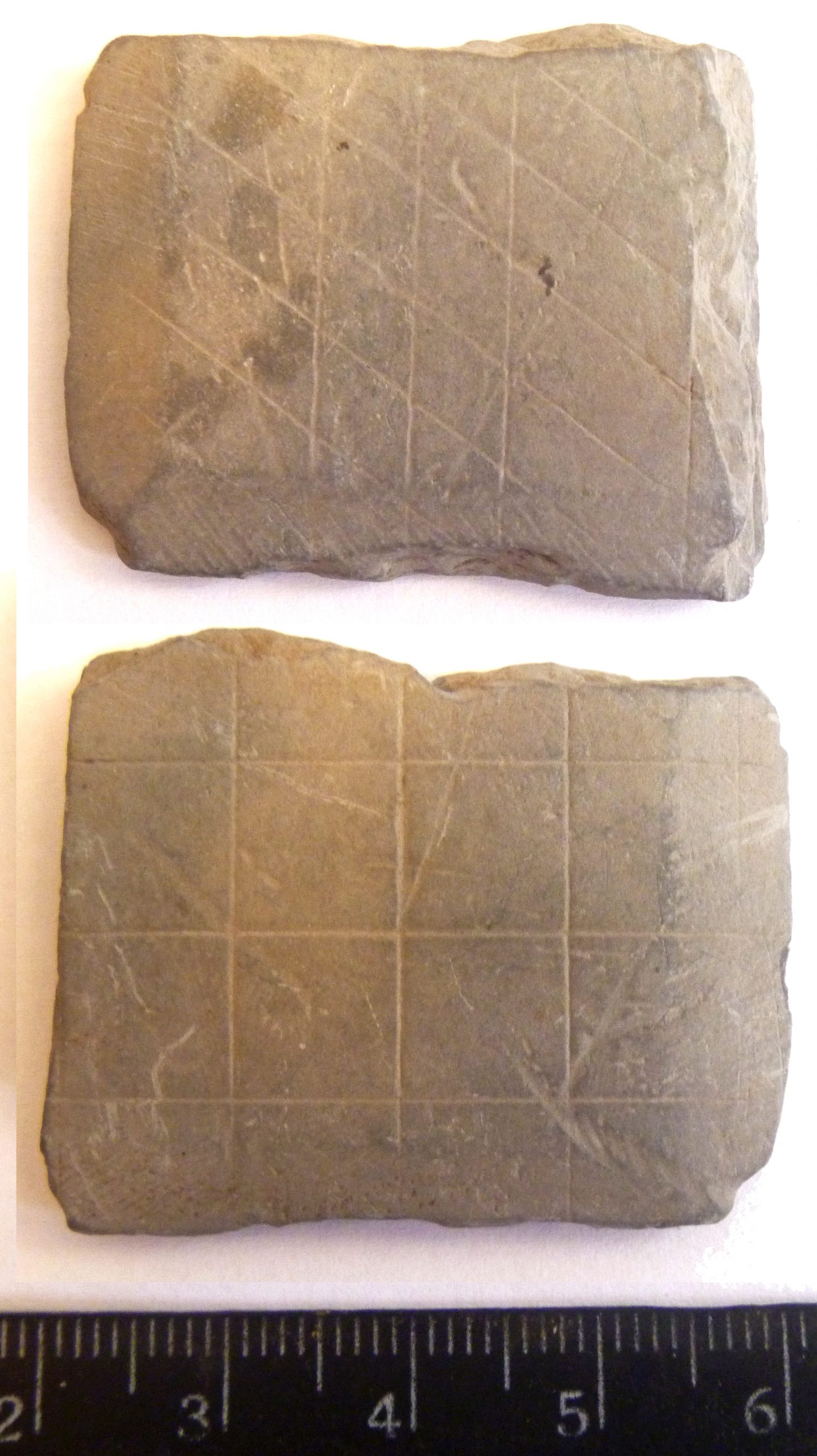
Сланцевий предмет з селища.
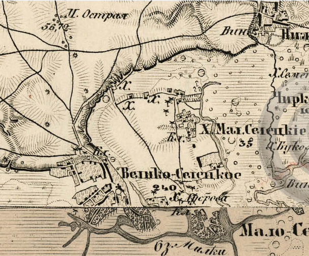
Карта місця розміщення пам’яток на сер. ХІХ ст. Основи: Военно-топографическая… Ряд ХХІІІ. Лист 11; Ряд ХХІV. Лист 11.
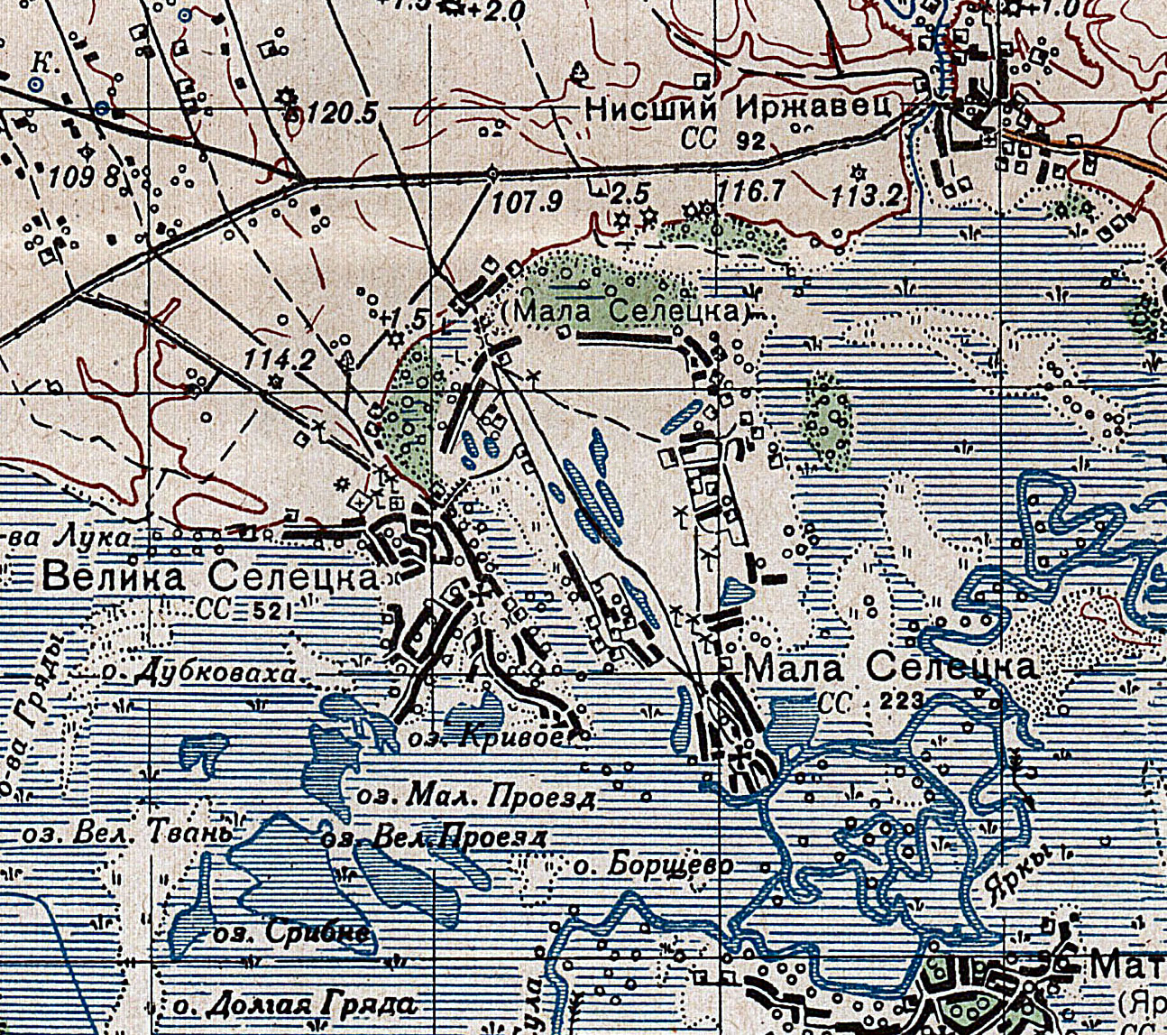
Деталь карти видання 1941 р. Основа: М-36-78. 1941
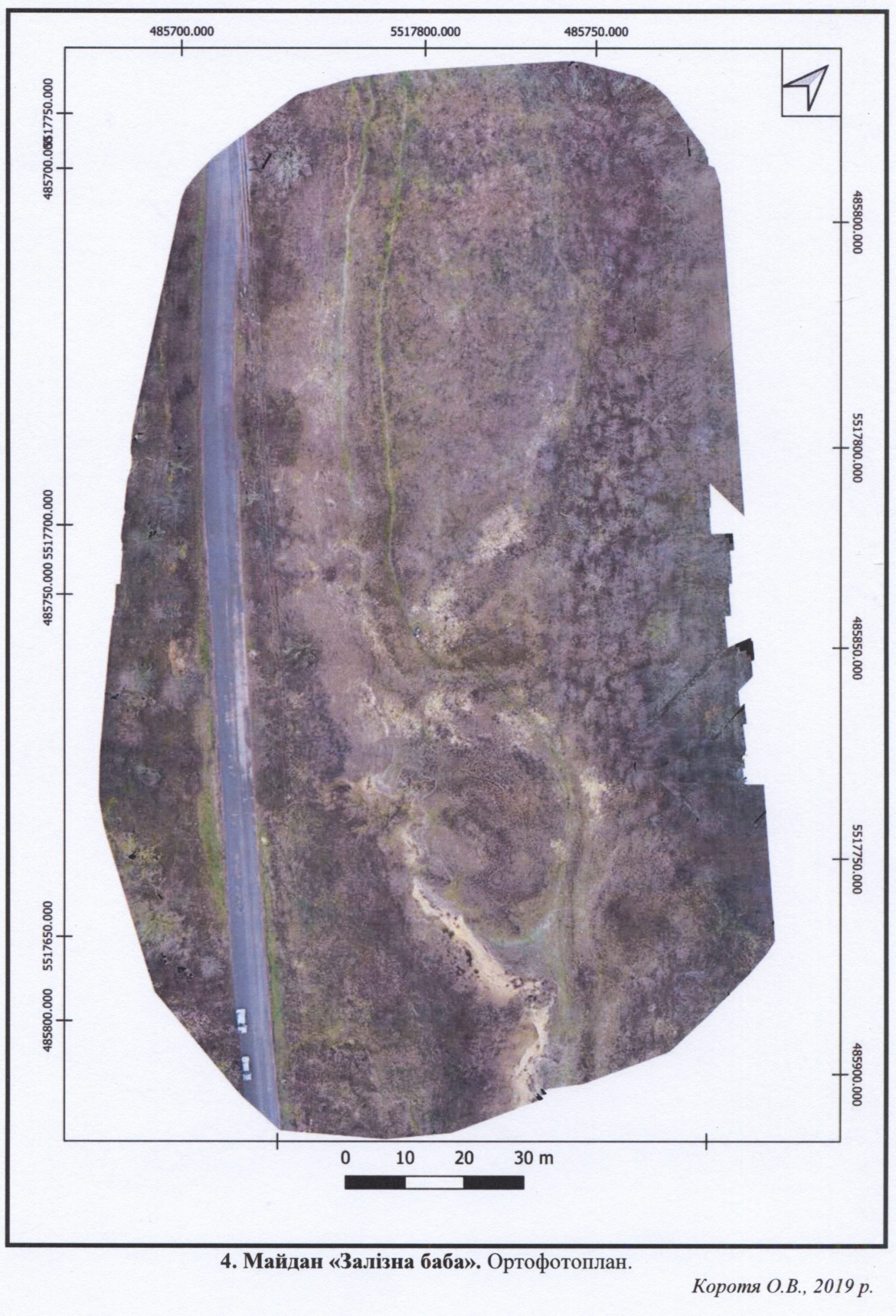
Майдан Залізна баба, Ортофотоплан. 2019 р. Виготовив О.В. Коротя
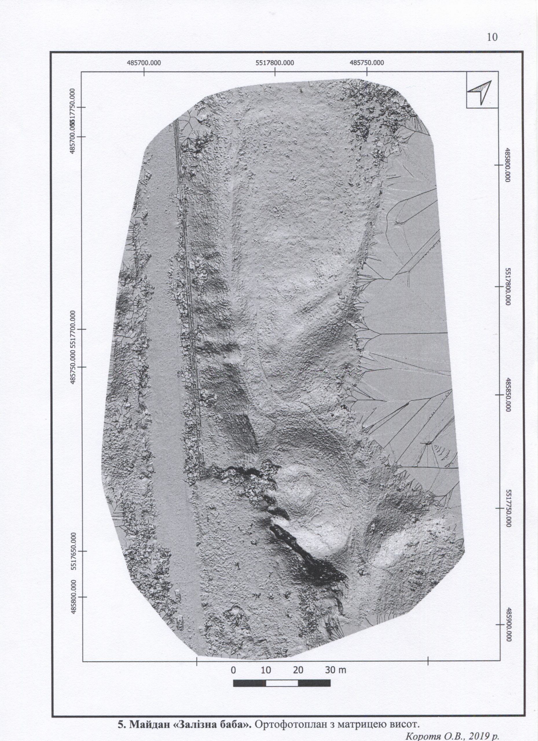
Майдан Залізна баба, Ортофотоплан з матрицею висот. 2019 р. Виготовив О.В. Коротя
Герб села Великоселецьке, затверджений рішенням сесії Селецької сільської ради від 05.05.2008 р. 5 скликання