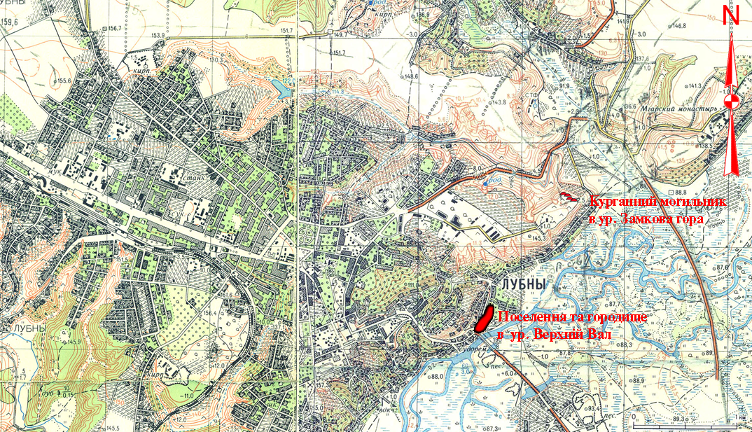
It is located in Lubny town, Lubny Town Council, Poltava region, Verkhnii Val, Oliinytsia, Kuliabky natural landmarks, 1.25-2.35 km to the east, north-east and south-east from the the Executive Committee building of Lubny Town Council; 0.385-0.962 km to the north-east, east and south-east from the memorial to soldiers who fell in action during the 2nd World War at the Slavy Square, opposite the motorway bridge across the Sula river.
The territory was surveyed by H. S. Kyriakov and F.I. Kaminskyi (the middle of 1870s), V. H. Liaskoronskyi (the beginning of 1890s). Minor surveys were conducted by M. V. Kuznietsova (1939). Later it was examined by F. B. Kopylov (1945, 1950 and 1953) and I. I. Liapushkin (1947). The excavations were carried out by O.V. Sukhobokov (1981-1982) (survey area made up 310 sq. m.). The inventory inspection was held by O. B. Suprunenko and K.M. Myronenko in 2015.
The settlement of the Chalcolithic Age, the Bronze Age, the Scythian era, Romen culture and Old-Russian period (the chronicle “town” Lubno), the remains of fortified settlement and the centre of regiment fortress – Lubny town of the Cossacks times, is located in the eastern and south-eastern part of the town. Verkhnii Val cultural layers, especially in uphill south-western part of residual where the Romen and Old Russian fortified settlement was located, are the thickest among all the fortifications of Slavic, Old Russian and Cossacks times in the Poltava region. Their capacity varies from 1.8 m to 2.5 m, and they reach up to 5.3 m in the central part of the Castle near the breastwork.
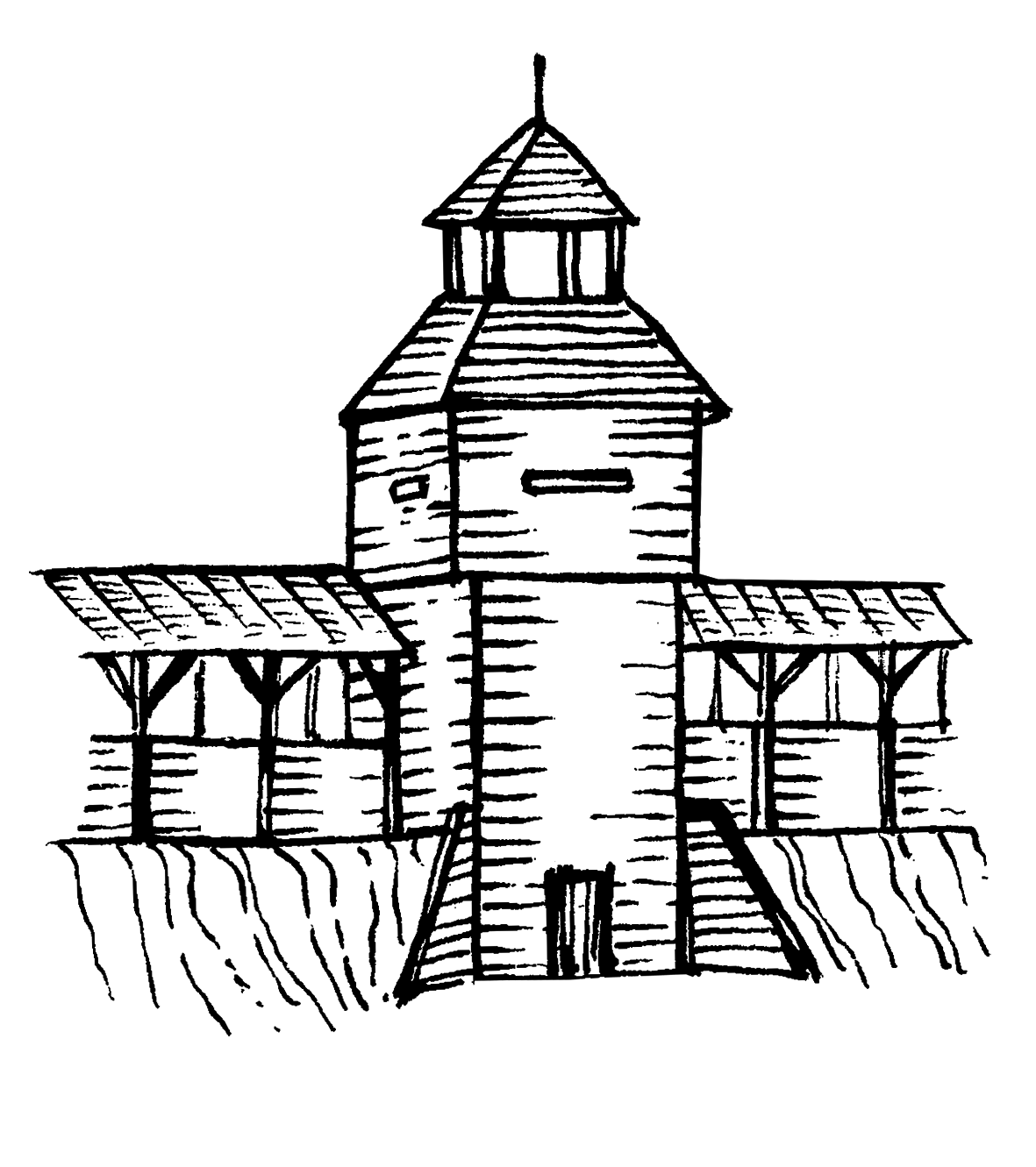
The uphill south-western area of residual (former Velykyi Zamok (Big Castle)) has the dimensions of 360 х 120–140 m and its area, consequently, is more 4.5 ha. There are remains of the powerful hood (canopy) breastwork, additionally filled in 17th –18th cc., as well as the remains of ditch of Old Russian and Cossacks times. The attempt to make breastwork rabotage was taken by O.V. Sukhobokov in 1982. In this part of Verkhnii Val (Upper Breastwork) there were the original embankments of the fortified settlement for chronicle “town” Lubno, which, as it appears, was better fortified part of the adjacent “upper” stockaded town of the Old Russian complex.
The slightly downhill section of residual is located in the north-eastern part at 2-i Verkhnii Val Str. (the location of Malyi Zamok (Small Castle)). The dimensions are 310 х 130–170 m and the area, correspondingly, makes up approximately 4 ha. In latitude direction the residual section along 2-i Verkhnii Val Str. is crossed by the remains of Malyi Zamok breastwork 0.8-1.5 m high and 4-6 m wide. A big (30 m in diameter) hollow is preserved in one of the vegetable gardens. It can belong to the fortress well subside, similar to well-known ones in Old Russian towns of Lower Posullia, mainly, Sniprorod near Matskivtsi village, Lubny district. The remains of Romen settlement and the fortified Old Russian stockaded town are observable at the beginning of Verkhnii Val northern part.
The built-up slope strip near the foot of Verkhnii Val remains from the south-east, along the Sula River, are actually the remains of the lowland township and the regimental city plain at the foot of a hill (Podil) (area is about 6.3 hectares).
So, the complex has a well-defined landscape dominant features and the centre of the historical landscape in Verkhnii Val – Zamok natural landmark, the remains of breastworks, trading quarters and picturesque hollows of the ancient ravines with historical names, thus, belonging to one of the most distinguished sites at Nyzhnosulsyi boundary of the Kyivan Rus. To the south-west from it, along the slopes of the right root bank of the Sula River, there was the Posullia defence line of Rus, constructed in times of Volodymyr Sviatoslavych (after 988). It was used to protect Pereiaslav and Kyiv from the attacks of the nomads.
It worth noting that the chronicle “town” Luben was mentioned in Volodymyr Monomakh’ Homily in the description of the events of 1107, as well as in paragraph dedicated to the year of 1107 in Laurentian and Hypatian codices of The Tale of Bygone Years.
4th – the beginning of 3rd, 2nd millennium BC, the Chalcolithic Age – the Bronze Age, 6th –4th cc. BC, the Scythian times, 9th –10th, 11th – the beginning of 13th cc., Romen culture, the Kyivan Rus period, the end of 16th –18th cc., Cossacks times.
It is located in Lubny town, Lubny Town Council, Poltava region, Verkhnii Val, Oliinytsia, Kuliabky natural landmarks, 1.25-2.35 km to the east, north-east and south-east from the the Executive Committee building of Lubny Town Council; 0.385-0.962 km to the north-east, east and south-east from the memorial to soldiers who fell in action during the 2nd World War at the Slavy Square, opposite the motorway bridge across the Sula river.
The territory was surveyed by H. S. Kyriakov and F.I. Kaminskyi (the middle of 1870s), V. H. Liaskoronskyi (the beginning of 1890s). Minor surveys were conducted by M. V. Kuznietsova (1939). Later it was examined by F. B. Kopylov (1945, 1950 and 1953) and I. I. Liapushkin (1947). The excavations were carried out by O.V. Sukhobokov (1981-1982) (survey area made up 310 sq. m.). The inventory inspection was held by O. B. Suprunenko and K.M. Myronenko in 2015.
The settlement of the Chalcolithic Age, the Bronze Age, the Scythian era, Romen culture and Old-Russian period (the chronicle “town” Lubno), the remains of fortified settlement and the centre of regiment fortress – Lubny town of the Cossacks times, is located in the eastern and south-eastern part of the town. Verkhnii Val cultural layers, especially in uphill south-western part of residual where the Romen and Old Russian fortified settlement was located, are the thickest among all the fortifications of Slavic, Old Russian and Cossacks times in the Poltava region. Their capacity varies from 1.8 m to 2.5 m, and they reach up to 5.3 m in the central part of the Castle near the breastwork.
The uphill south-western area of residual (former Velykyi Zamok (Big Castle)) has the dimensions of 360 х 120–140 m and its area, consequently, is more 4.5 ha. There are remains of the powerful hood (canopy) breastwork, additionally filled in 17th –18th cc., as well as the remains of ditch of Old Russian and Cossacks times. The attempt to make breastwork rabotage was taken by O.V. Sukhobokov in 1982. In this part of Verkhnii Val (Upper Breastwork) there were the original embankments of the fortified settlement for chronicle “town” Lubno, which, as it appears, was better fortified part of the adjacent “upper” stockaded town of the Old Russian complex.
The slightly downhill section of residual is located in the north-eastern part at 2-i Verkhnii Val Str. (the location of Malyi Zamok (Small Castle)). The dimensions are 310 х 130–170 m and the area, correspondingly, makes up approximately 4 ha. In latitude direction the residual section along 2-i Verkhnii Val Str. is crossed by the remains of Malyi Zamok breastwork 0.8-1.5 m high and 4-6 m wide. A big (30 m in diameter) hollow is preserved in one of the vegetable gardens. It can belong to the fortress well subside, similar to well-known ones in Old Russian towns of Lower Posullia, mainly, Sniprorod near Matskivtsi village, Lubny district. The remains of Romen settlement and the fortified Old Russian stockaded town are observable at the beginning of Verkhnii Val northern part.
The built-up slope strip near the foot of Verkhnii Val remains from the south-east, along the Sula River, are actually the remains of the lowland township and the regimental city plain at the foot of a hill (Podil) (area is about 6.3 hectares).
So, the complex has a well-defined landscape dominant features and the centre of the historical landscape in Verkhnii Val – Zamok natural landmark, the remains of breastworks, trading quarters and picturesque hollows of the ancient ravines with historical names, thus, belonging to one of the most distinguished sites at Nyzhnosulsyi boundary of the Kyivan Rus. To the south-west from it, along the slopes of the right root bank of the Sula River, there was the Posullia defence line of Rus, constructed in times of Volodymyr Sviatoslavych (after 988). It was used to protect Pereiaslav and Kyiv from the attacks of the nomads.
It worth noting that the chronicle “town” Luben was mentioned in Volodymyr Monomakh’ Homily in the description of the events of 1107, as well as in paragraph dedicated to the year of 1107 in Laurentian and Hypatian codices of The Tale of Bygone Years.
4th – the beginning of 3rd, 2nd millennium BC, the Chalcolithic Age – the Bronze Age, 6th –4th cc. BC, the Scythian times, 9th –10th, 11th – the beginning of 13th cc., Romen culture, the Kyivan Rus period, the end of 16th –18th cc., Cossacks times.
Read moreПам’яткоохоронна інформація
Monument protection information
Фотогалерея
Gallery
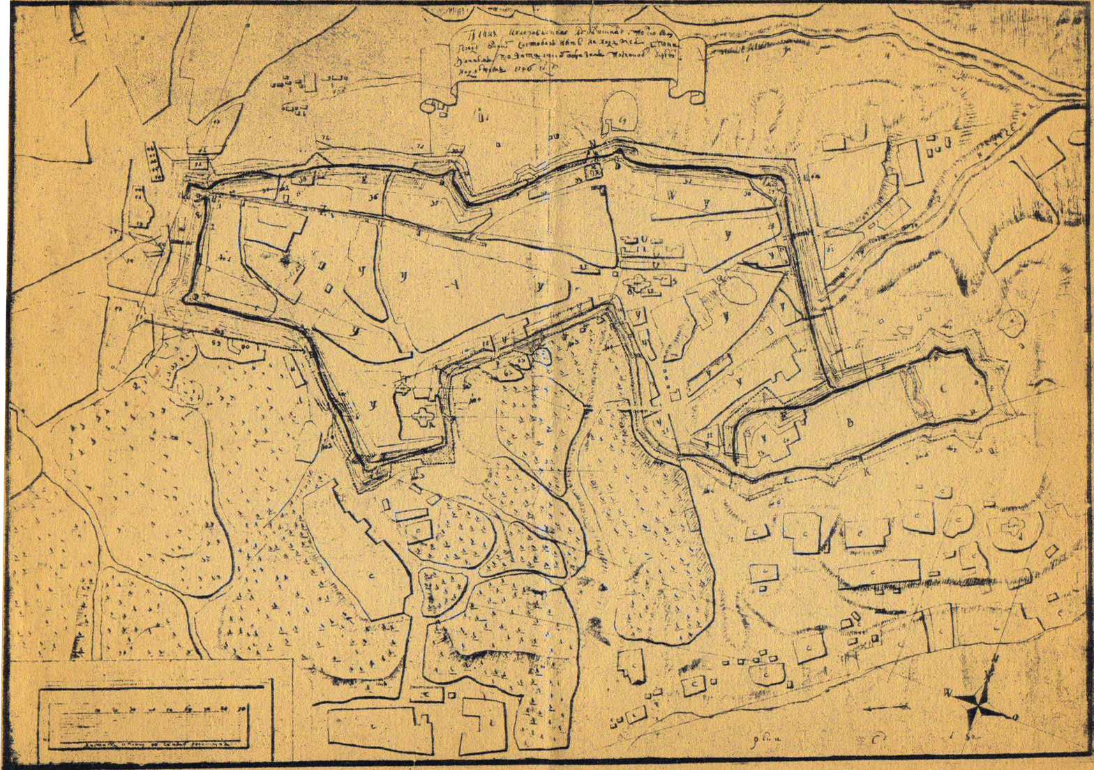
Лубни, м. Давньоруське городище «Лубно», ур. Верхній Вал. План малороссийскому Лубенскому полковому городу. 1748 года.
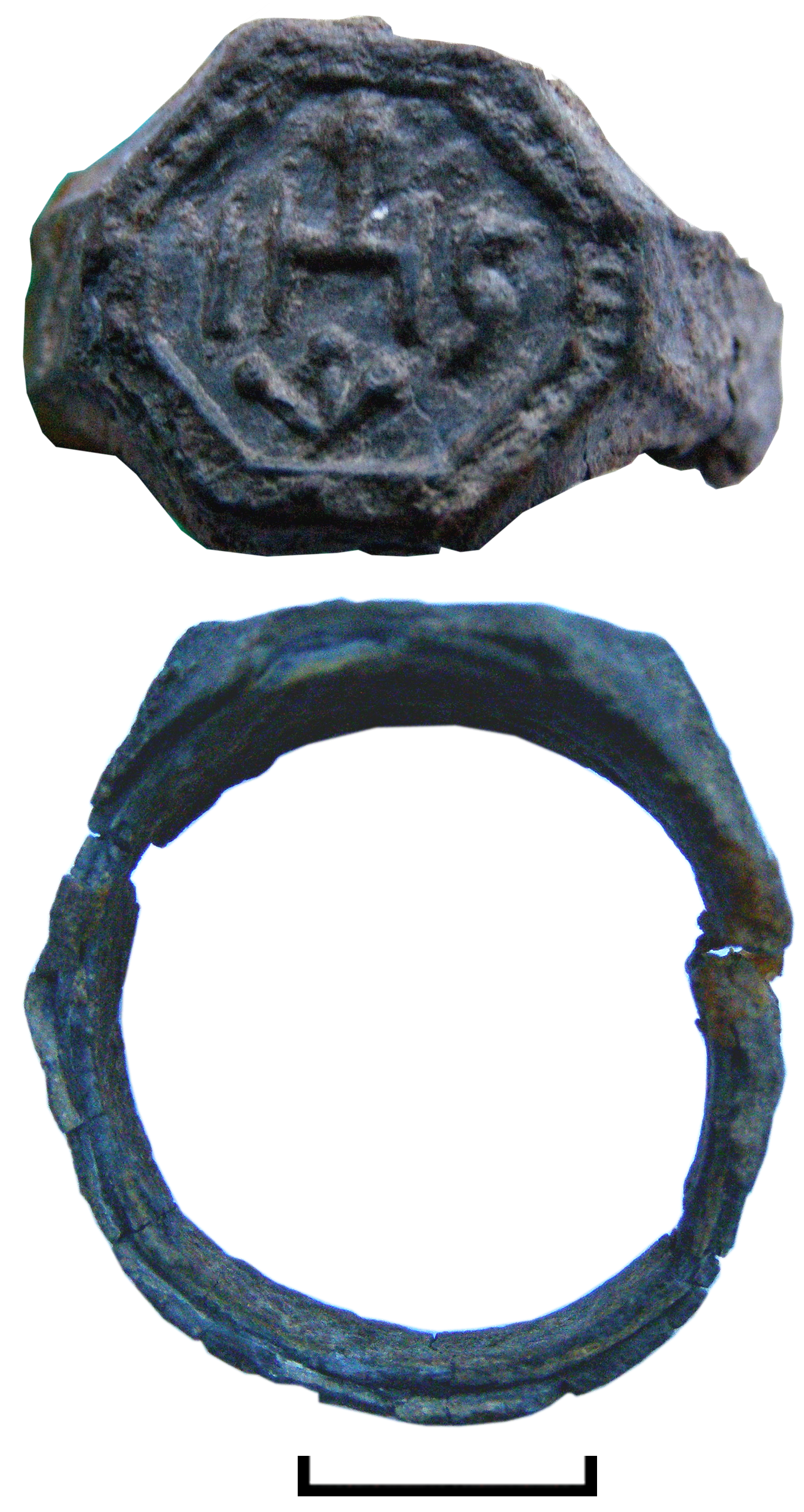
Лубни, м. Давньоруське городище «Лубно», ур. Верхній Вал. Перстень з поховання кін. XVI – XVII ст. Бронза.