It is located in Horodyshche village Melekhy Village Council, Chornukhy district, Poltava region, at the north-eastern uphill edge of the village, in Zamok natural landmark, next to Lubny-Chornukhy motorway (Т-17-14).
It has been known from the sources of 17th –18th cc. and statistical surveys of the end of 19th cc. It was examined and surveyed by V. M. Shcherbakivskyi (1918), M.D. Renskyi (1921 and 1924), by O.V. Sukhobokov and M. P. Kuchera (1971). Minor surveys were also conducted by V. V. Pryimak (1995).
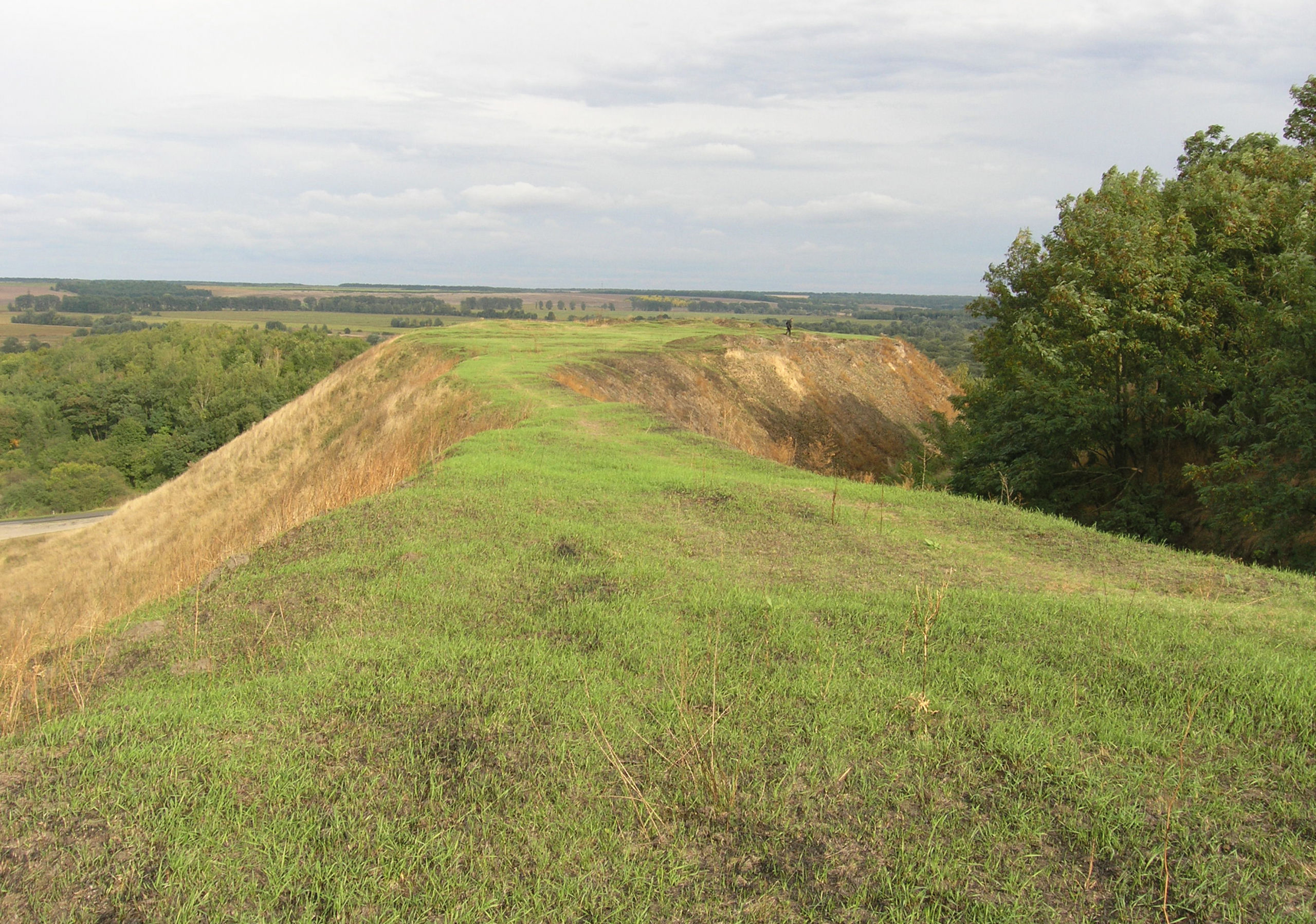
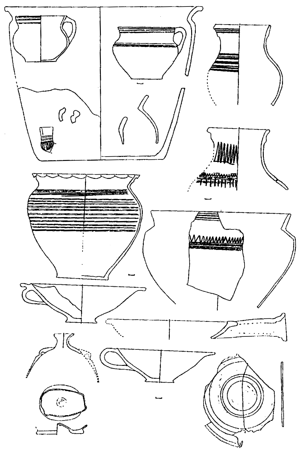
The fortified settlement is located on the uphill spur of floodplain terrace on the left bank of the Udai River and the Mnoha River. The townships are adjacent to its territory from the western and the eastern part. The remains of bloated breastworks (height – 0.20-0.50 m, length – 15-25 m), as well as the traces of slopes scarping are observable at the settlement square. The square area is 0.80 hectares. The capacity of cultural layers is 0.20 – 1.50 m, where the findings of Romen moulded dishes and Old Russian ceramics can be distinguished, though, their base is formed by separate artefacts of the Bronze Age (Pyvykhynska culture). Among separate findings one can also distinguish a slant pointer made of roe deer horn with its end in form of the wolf’s bare teeth, similar to the Varangians traditions (10th c.). In 1995 several middens of the Romen culture and a dwelling f the Cossacks times were surveyed.
Township I is located at the western side of the fortified settlement. The findings are dispersed on the area of 1.25 ha. The remains of the Romen moulded dishes, Old Russian dish ware and Byzantine vases were discovered there.
Township II is located at the eastern side. The thickness of the cultural layers makes up 0.4 m.
Burial mound I had been destroyed by the construction of the landowner’s estate. Several embankments were surveyed by V. M. Shcherbakivskyi, M. D. Renskyi and V. V. Pryimak.
Burial mound II comprises 2 groups, that used to include 300 banks, but only 12 of them have been preserved until now. Its height is 0.20-0.30 m, diameters are 5-11 m. At the beginning of 20th c. 18 burial sites were surveyed.
Several treasures, discovered at the beginning of 19th c., come from the surroundings of the fortified settlement and the townships.
L.V. Padalka and V. V. Pryimak made some points about the connection of the fortified settlement remains with well-known Mnoha settlement of the Cossacks times.
4th –2nd millennium BC, 6th –4th cc. BC, 9th –11th, 11th –14th, 17th –18th cc. The Chalcolithic Age – the Bronze Age, the Scythian times, Romen culture, the Kyivan Rus period, post-Mongol period and late Ukrainian Middle Ages.
It is located in Horodyshche village Melekhy Village Council, Chornukhy district, Poltava region, at the north-eastern uphill edge of the village, in Zamok natural landmark, next to Lubny-Chornukhy motorway (Т-17-14).
It has been known from the sources of 17th –18th cc. and statistical surveys of the end of 19th cc. It was examined and surveyed by V. M. Shcherbakivskyi (1918), M.D. Renskyi (1921 and 1924), by O.V. Sukhobokov and M. P. Kuchera (1971). Minor surveys were also conducted by V. V. Pryimak (1995).
The fortified settlement is located on the uphill spur of floodplain terrace on the left bank of the Udai River and the Mnoha River. The townships are adjacent to its territory from the western and the eastern part. The remains of bloated breastworks (height – 0.20-0.50 m, length – 15-25 m), as well as the traces of slopes scarping are observable at the settlement square. The square area is 0.80 hectares. The capacity of cultural layers is 0.20 – 1.50 m, where the findings of Romen moulded dishes and Old Russian ceramics can be distinguished, though, their base is formed by separate artefacts of the Bronze Age (Pyvykhynska culture). Among separate findings one can also distinguish a slant pointer made of roe deer horn with its end in form of the wolf’s bare teeth, similar to the Varangians traditions (10th c.). In 1995 several middens of the Romen culture and a dwelling f the Cossacks times were surveyed.
Township I is located at the western side of the fortified settlement. The findings are dispersed on the area of 1.25 ha. The remains of the Romen moulded dishes, Old Russian dish ware and Byzantine vases were discovered there.
Township II is located at the eastern side. The thickness of the cultural layers makes up 0.4 m.
Burial mound I had been destroyed by the construction of the landowner’s estate. Several embankments were surveyed by V. M. Shcherbakivskyi, M. D. Renskyi and V. V. Pryimak.
Burial mound II comprises 2 groups, that used to include 300 banks, but only 12 of them have been preserved until now. Its height is 0.20-0.30 m, diameters are 5-11 m. At the beginning of 20th c. 18 burial sites were surveyed.
Several treasures, discovered at the beginning of 19th c., come from the surroundings of the fortified settlement and the townships.
L.V. Padalka and V. V. Pryimak made some points about the connection of the fortified settlement remains with well-known Mnoha settlement of the Cossacks times.
4th –2nd millennium BC, 6th –4th cc. BC, 9th –11th, 11th –14th, 17th –18th cc. The Chalcolithic Age – the Bronze Age, the Scythian times, Romen culture, the Kyivan Rus period, post-Mongol period and late Ukrainian Middle Ages.
Read moreПам’яткоохоронна інформація
Monument protection information
Пам’ятка археології місцевого значення.
Наказ Міністерства культури, молоді та спорту України № 1062 від 25.02.2020 р.
охоронний номер 2975-Пл.
chornuhynskyj-rn-s.-gorodyshhe-gorodyshhe-poselennya-ta-mogylnyk-v-ur-zamok-pasport.pdfПам’ятка археології місцевого значення.
Наказ Міністерства культури, молоді та спорту України № 1062 від 25.02.2020 р.
охоронний номер 2975-Пл.
chornuhynskyj-rn-s.-gorodyshhe-gorodyshhe-poselennya-ta-mogylnyk-v-ur-zamok-pasport.pdfНаукові публікації
Scientific publications
Моргунов Ю., Приймак В., Супруненко О. Археологічний комплекс: городище “Многинське” та селище І-ІІ // Звід пам’яток історії та культури України: Полтавська область. Чорнхинський район / Упоряд. В. О. Мокляк; підгот. до друку і редаг. В. О. Мокляка, О. Б. Супруненка; передм. В. О. Мокляка, О. Б. Супруненка, В. В. Приймака, І. Ю. Бикова; авт. статей: В. А. Андрієць, І. Ю. Биков, С. І. Бочарова та інш.; УК ПОДА; ЦОДПА; ПКМ імені Василя Кричевського. – Полтава : ТОВ «АСМІ», 2017. – С. 162-168
chornuhynskyj-zvod-gorodyshhe-gorodyshhe-poselennya-miscz-pam.pdfМоргунов Ю., Приймак В., Супруненко О. Археологічний комплекс: городище “Многинське” та селище І-ІІ // Звід пам’яток історії та культури України: Полтавська область. Чорнхинський район / Упоряд. В. О. Мокляк; підгот. до друку і редаг. В. О. Мокляка, О. Б. Супруненка; передм. В. О. Мокляка, О. Б. Супруненка, В. В. Приймака, І. Ю. Бикова; авт. статей: В. А. Андрієць, І. Ю. Биков, С. І. Бочарова та інш.; УК ПОДА; ЦОДПА; ПКМ імені Василя Кричевського. – Полтава : ТОВ «АСМІ», 2017. – С. 162-168
chornuhynskyj-zvod-gorodyshhe-gorodyshhe-poselennya-miscz-pam.pdfФотогалерея
Gallery
Городище, с. Давньоруське городище ур. Замок. Загальний вигляд. Фото 2007 р.
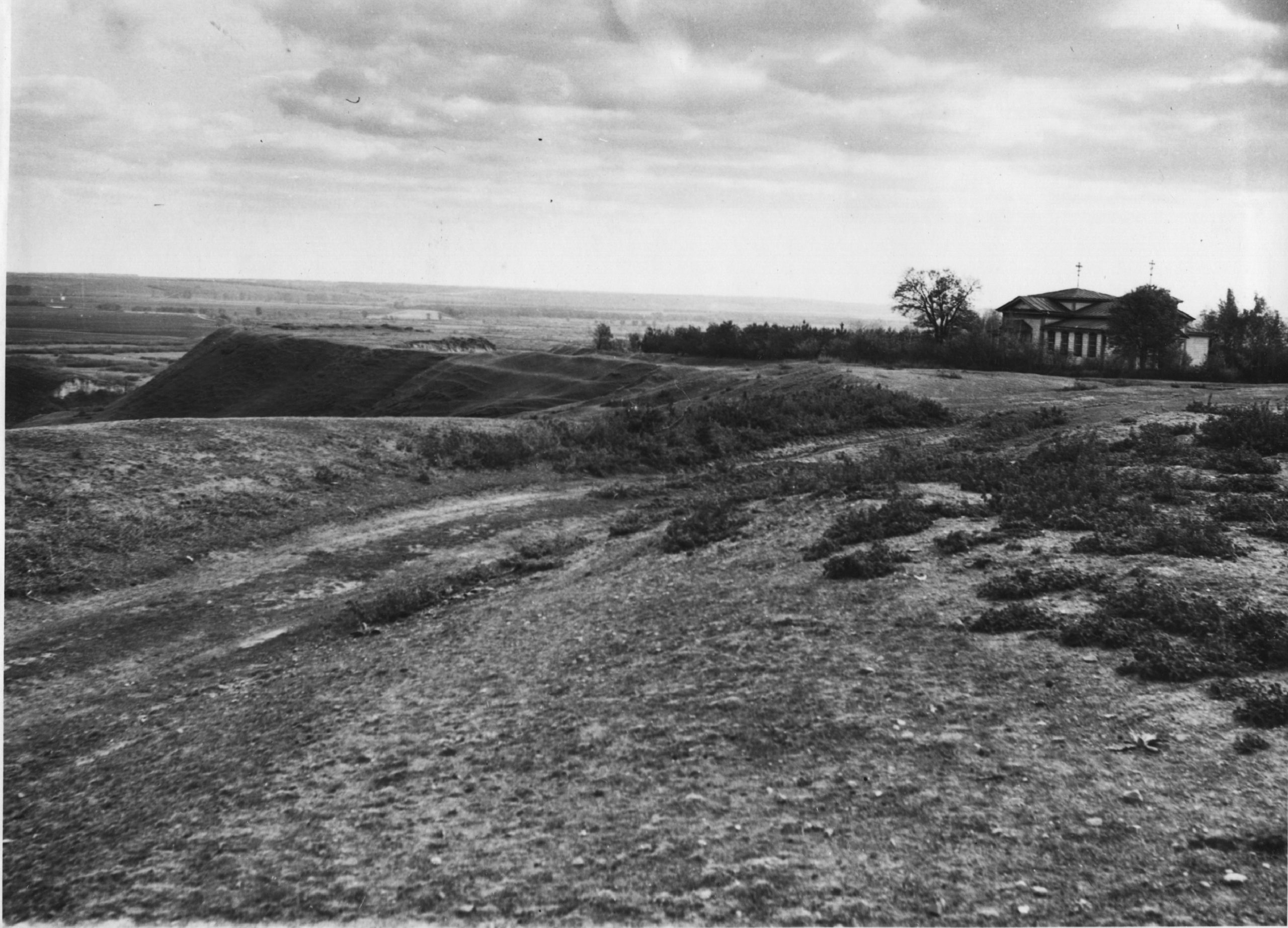
Городище, с. Давньоруське городище ур. Замок. Фото 1975 р.
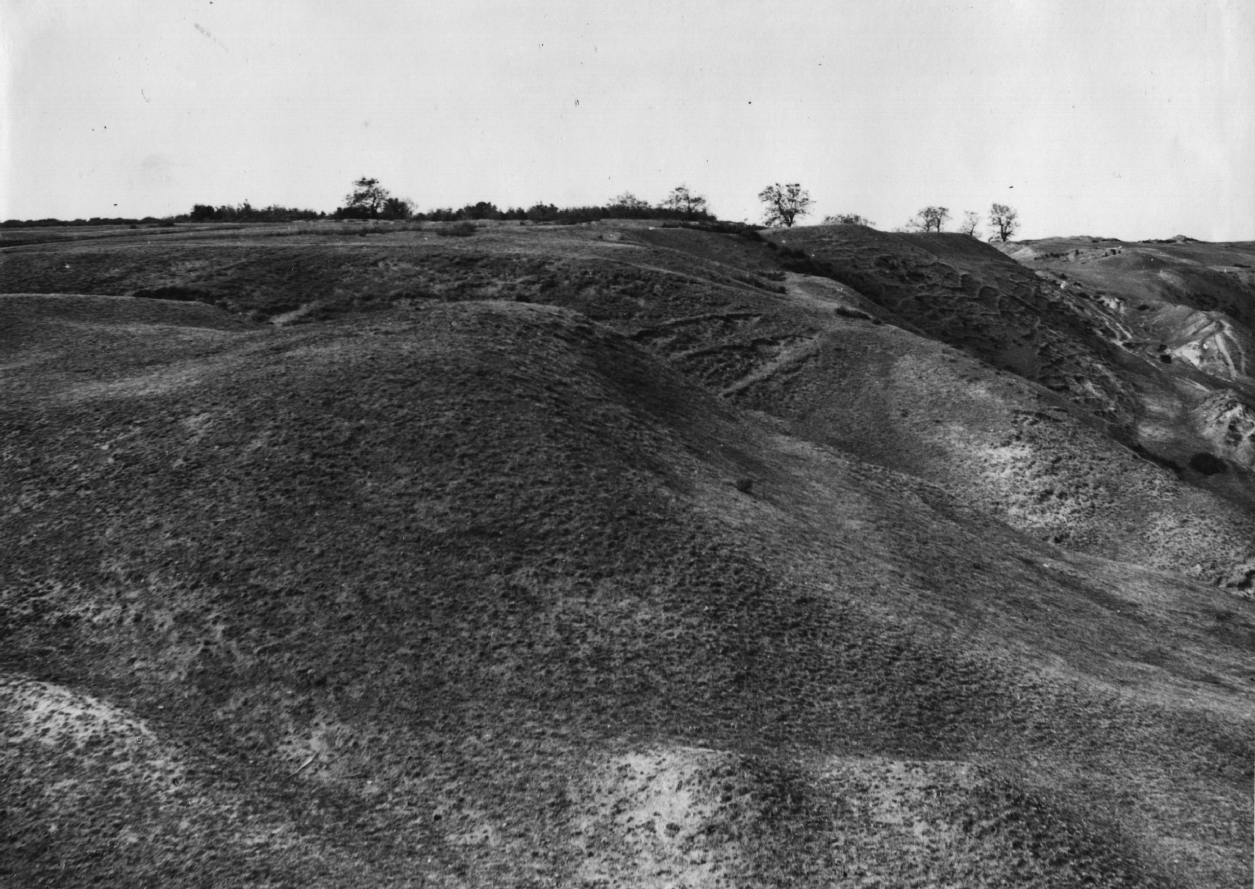
Городище, с. Давньоруське городище ур. Замок. Фото 1975 р.
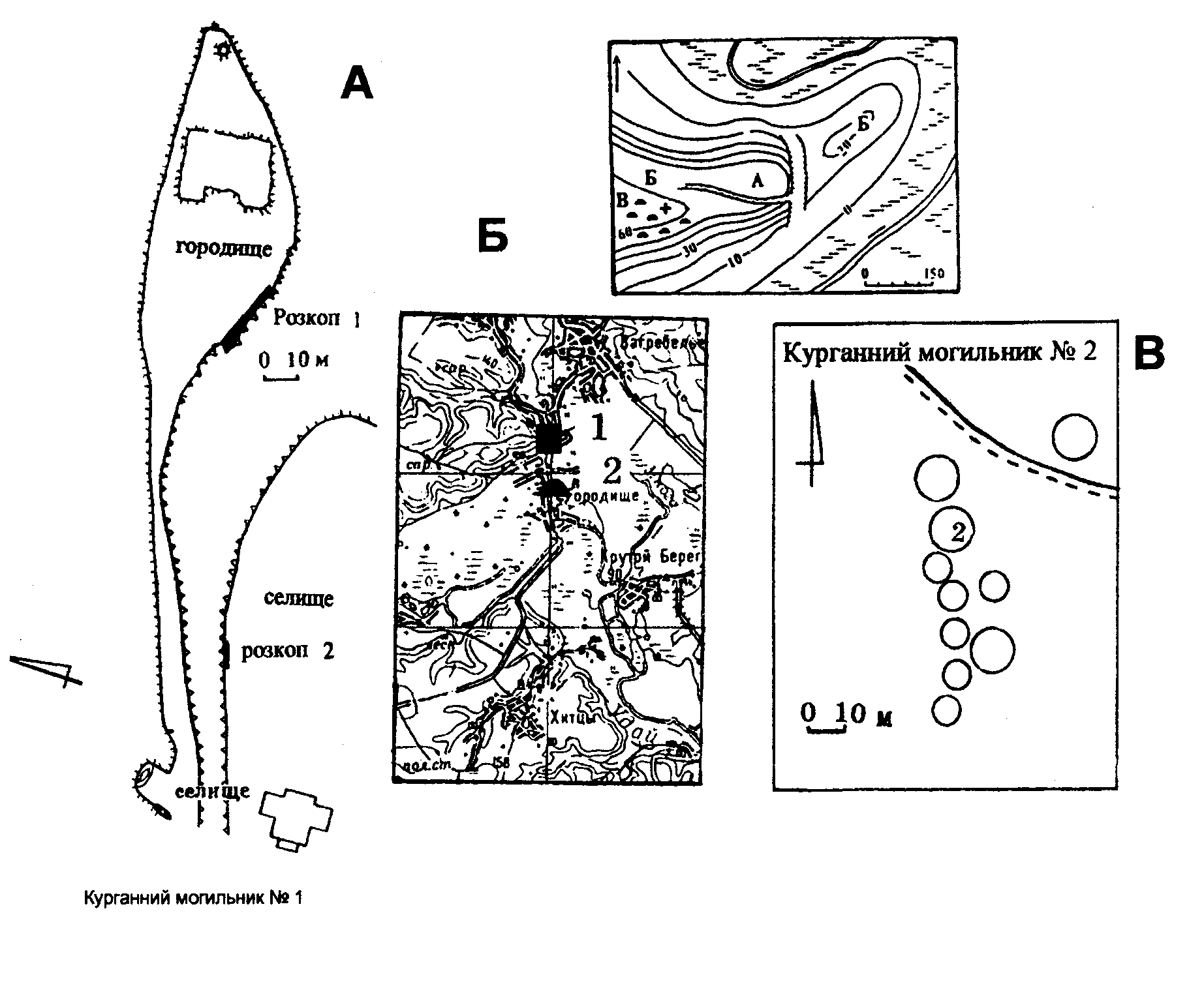
Городище, с. Давньоруське городище ур. Замок. План городища та курганного могильника за Ю.Ю. Моргуновим та В.В. Приймаком.
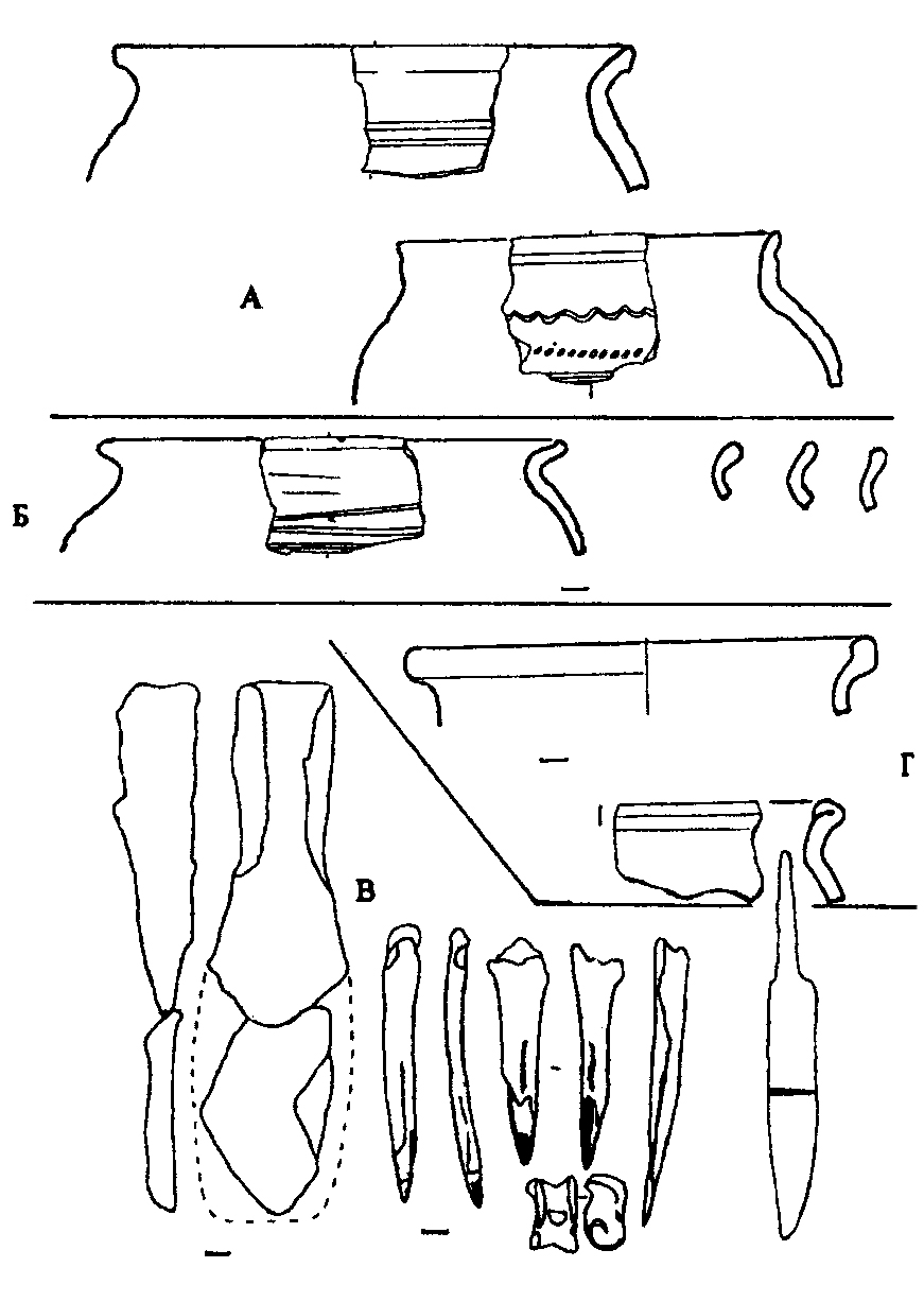
Городище, с. Давньоруське городище ур. Замок. Знахідки із городища. Дослідження В.В. Приймака, 1995 р.
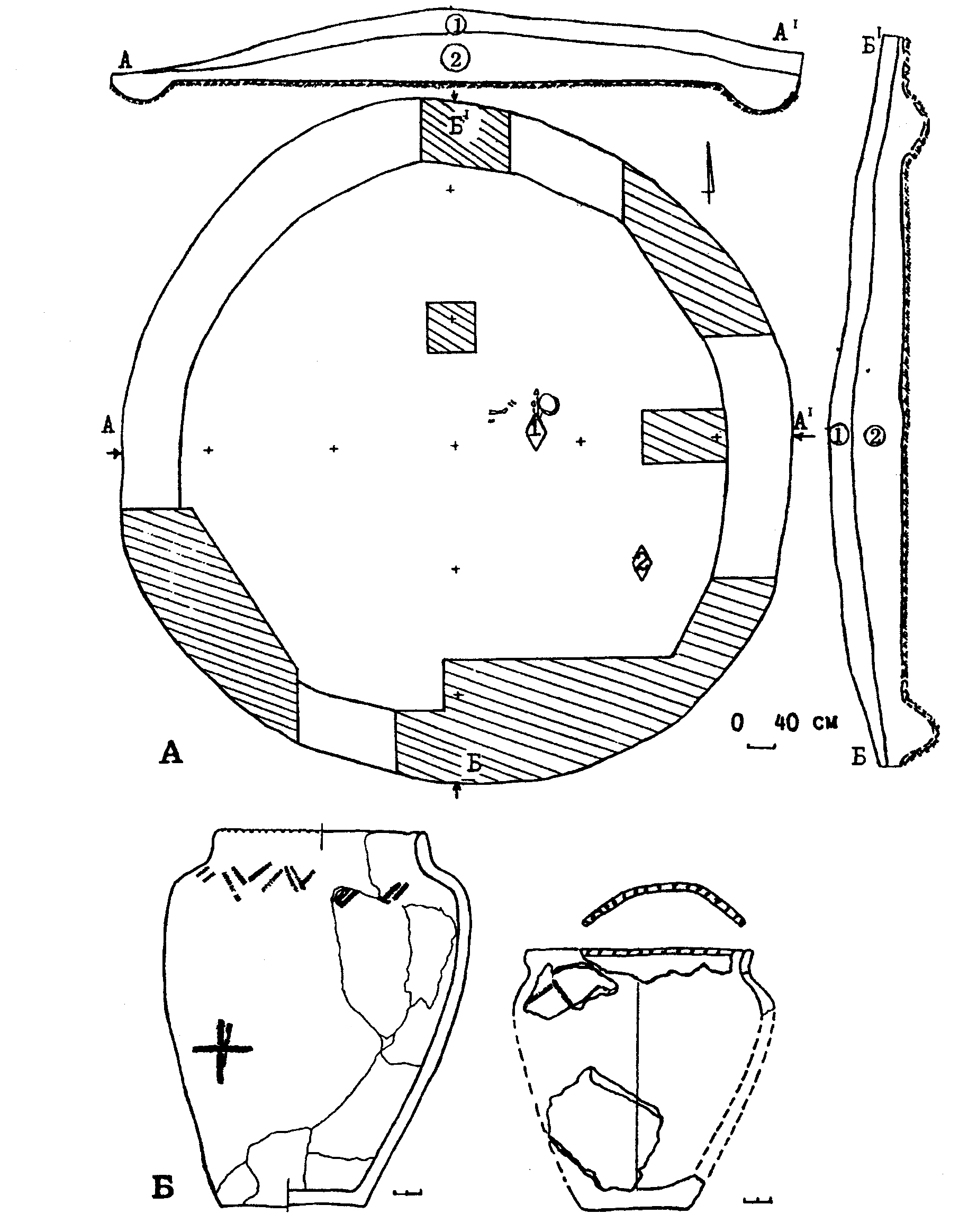
Городище, с. Давньоруське городище ур. Замок. Курганний могильник ІІІ. Курган 2/1995. План та знахідки із кургану. Дослідження В.В. Приймака.
Городище, с. Давньоруське городище ур. Замок. Посуд козацького часу.
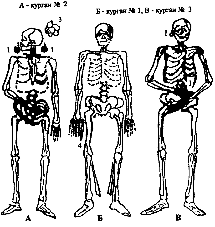
Городище, с. Давньоруське городище ур. Замок. План поховань за В.М. Щербаківським, 1918 р.